Windy Pass - 3.12.2008
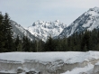
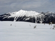
Chikamin Peak from the Hyak Sno-Park (2640')... Exit 54... west side of I-90.
|
Looking back on the Hyak Sno-Park... Denny Mtn on the left... Guye Peak and Mt. Snoqualmie on the right.
|
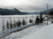
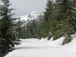
Reach Keechelus Lake in less than a half mile.
|
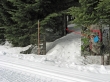
Approximately one mile from the Hyak Sno-Park this orange pole is where you leave the road and hike or ski an eighth of a mile in the woods.
|
Turn left when you come out of the woods... on the Cold Creek road.
|
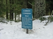
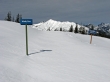
Stay on the main road and don't be tempted by any junctions... when you see this sign you know you are on the right path.
|
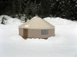
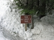
One of the ski huts furnished by the Hyak XC Ski Center... for paying customer use only.
|
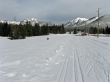
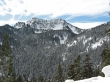
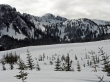
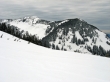
My first look at Silver Peak... after skiing for 3.5 to 4 miles.
|
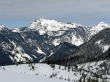
Tinkham Peak from along the road to Windy Pass and Olallie Meadows.
|
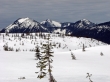
After 5 miles of skiing I arrive at Windy Pass in Olallie Meadows... Granite Mtn in the distance... let the views begin.
|
Left to right... Kaleetan Peak, Chair Peak, Bryant Peak, The Tooth, and Denny Mtn.
|
A closeup of Kaleetan Peak, Chair Peak, Bryant Peak, and The Tooth.
|
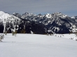
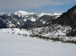
Looking across Olallie Meadows to Silver Peak.
|
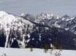
Bandera Mtn, Mt. Defiance, and Pratt Mtn.
|
A closeup of Mt. Snoqualmie, Lundin Peak, and Red Mtn (looks white to me)... Guye Peak is in the foreground.
|
Mt. Snoqualmie, Lundin Peak, Red Mtn, the top of Mt. Thomson, and Kendall Peak... Guye Peak is in the foreground.
|
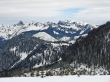
Granite Mtn... with Kaleetan, Chair, and Bryant on the right.
|
I made an upward traverse higher into Olallie Meadows for this shot of Humpback Mtn.
|
As I skiied higher in Ollalie Meadows, Chimney Rock and Chikamin Peak were visible on the right... Mt. Thomson and Kendall Peak on the left.
|
A panorama shot from my hight point (4160') in Ollalie Meadows... Granite Mtn on the left to Rampart Ridge on the right... 10.5 miles roundtrip, gaining 1500 feet of elevation.
|
