Freedom Peak - 6.18.2008
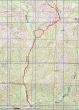
rodman's GPS route for Freedom Peak... 8 miles roundtrip, gaining 3485 feet of elevation.
|
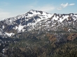
Freedom Peak from the rib that will take us to the ridge southeast of the peak.
|

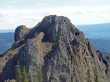
rodman and larman are on the ridge that will take us to the Freedom Peak summit.
|
larman on Freedom Peak (6442')... Navaho Peak is in the center foreground and the Stuart Range is behind Navaho.
|
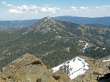
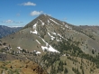
Miller Peak from Freedom Peak.
|
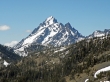
A closeup of Mt. Stuart and Sherpa Peak from Freedom Peak.
|
A closeup of Earl Peak from Freedom Peak.
|
The west summit of Three Brothers from Freedom Peak.
|
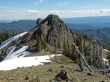
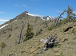
We had to get around this bump on the way to Freedom Peak and on our way back to the car.
|
And the best way to get around the bump was to go up and over it.
|
