Cowboy Mountain and Big Chief Mountain - 7.12.2008
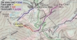
Map showing our route to Cowboy Mtn and Big Chief Mtn... started (4056') on the ski area road to Cowboy... across Cowboy to the Crest trail... then out to Big Chief... back to the Crest trail and down to the car... 8.5 miles roundtrip, gaining 2850 feet of elevation.
|
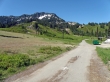
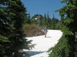
Hiking on the Stevens Pass ski area road towards Cowboy Mtn.
|
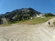
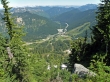
Gaining elevation on the ski area road... you can see the road winding up towards the top of the Barrier Mtn chair-lift to the right of Cowboy Mtn.
|
At the top of the Barrier Mtn chair-lift you see the Seventh Heaven chair-lift.
|
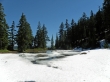
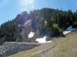
We hiked beyond the Barrier Mtn chair-lift and passed this small pond.
|
Continuing past the small pond, we gained some elevation and got a nice view of Glacier Peak in the distance.
|
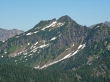
After gaining another 600' of fairly steep elevation, Nanda and Denali Girl are on the Cowboy Mtn summit (5853')... Glacier Peak in the distance.
|
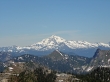
A closeup of Glacier Peak from the Cowboy Mtn summit... the small mountain in the center foreground is Mt. McCausland.
|
Looking down on the Stevens Pass ski area from the Cowboy Mtn summit.
|
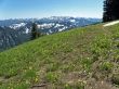
Continuing across Cowboy and down its east side, we gave back 600 feet of elevation on steep terrain that pushed us off of the ridge.
|
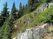
larman and Denali Girl continue on steep terrain underneath a rock outcropping along the ridge from Cowboy Mtn to the PCT.
|
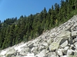
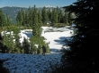
Denali Girl is crossing this much welcomed boulder field... the Cowboy Mtn summit is above.
|
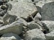
A marmot keeps an eye on us as we cross his boulder field.
|
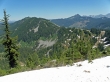
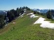
Regaining 200' of elevation back up to the ridge gives this view of Big Chief Mtn on the left... we will continue along this ridge over to Big Chief... Jim Hill Mtn is to the right of Big Chief.
|
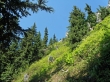
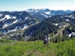
Denali Girl hiking along the ridge from Cowboy Mtn (behind her) towards the PCT.
|
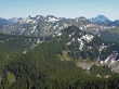
We crossed the PCT and 1.5 miles of easy hiking brought us to the Big Chief Mtn summit (5858')... Lake Valhalla sits at the foot of Mt. McCausland and Lichtenberg Mtn... Mt. Baker in the distance.
|
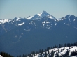
A closeup of Jim Hill Mtn from the Big Chief summit.
|
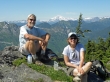
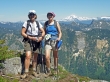
larman and Nanda on the Big Chief Mtn summit... with Glacier Peak in the distance.
|
Mt. Stuart is in the distance on the right... and I believe the Chiwaukum Mountains are in the foreground.
|
A closeup of The Cradle from Big Chief Mtn.
|
Tons of Glacier Lilies near the Big Chief summit... looking southwest towards Mt. Daniel and Mt. Hinman.
|
Hiking back along the ridge from Big Chief towards the PCT.
|
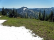
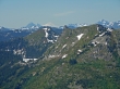
Cowboy Mtn from the ridge between Big Chief and the PCT.
|
Nanda and larman are almost back to where we will use the PCT to hike the last two miles back to the car.
|
3 or 4 miles west of Stevens Pass there is an interpretive center that provides info on the Great Northern Railroad and the 1910 Wellington avalanche that killed 96 people.
|
