Mount Ruth - 8.8.2008
Start from the White River Campground (4300')... hike 3 miles to Glacier Basin (5900')... cross the water draining from the Inter Glacier... hike to the ridge (6735') NE of Mt. Ruth... and follow the ridge to Mt. Ruth (8690')... 11 miles roundtrip, gaining 4400 feet of elevation.
|
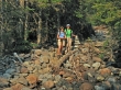
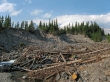
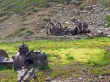
The first mile of trail from the White River Campground was destroyed in the 2006 floods... yellow tape helps hikers find the path.
|
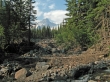
Little Tahoma is in the distance... beyond the flood destruction.
|
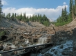
Mother Nature always wins...
|
Denali Girl and Nanda weave their way through the destruction.
|
Almost through the destruction now... a nice look at Little Tahoma.
|
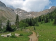
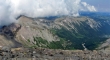
After 3 miles of hiking, we arrived at Glacier Basin.
|
I will cross the water draining from the Inter Glacier and hike up to the ridge on the far left.
|
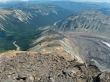
Shortly after crossing the water I found evidence of mining in the area... discontinued many years ago.
|
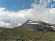
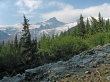
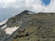
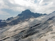
I used good path to get up to the ridge on the left... and my first good look at Mt. Ruth.
|
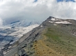
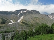
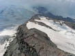
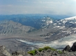
I've reached the ridge and I'm heading for Mt. Ruth... Mt. Rainier is in the clouds, but I do see part of the Emmons Glacier.
|
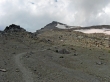
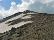
The Mt. Ruth summit is very deceiving... so close, yet so far.
|
Still trying to get to the Mt. Ruth summit.
|
Finally I can see the summit without any more bumps to cross over.
|
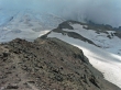
I've reached the ridge between Mt. Ruth and Steamboat Prow... with the Emmons Glacier on the left.
|
The west side of Mt. Ruth (8690')... I'll be on the summit in a few minutes.
|
The ridge leading from Mt. Ruth over to Steamboat Prow.
|
From the Mt. Ruth summit I am looking across the Emmons Glacier to Little Tahoma.
|
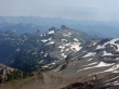
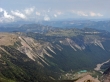
From Mt. Ruth I am looking across Glacier Basin to Third, Second, and First Burroughs Mountain.
|
From Mt. Ruth I am looking across Summerland and Panhandle Gap to the Cowlitz Chimneys.
|
Sunrise is in the meadow in the center of the photo.
|
From Mt. Ruth I am looking 2000 feet down to the ridge I used to get up to the summit... Goat Island Mtn on the right.
|
Looking across the lower part of the Emmons Glacier and Goat Island Mtn to Tamanos Mtn, Govenors Ridge, Barrier Peak, and the Cowlitz Chimneys.
|
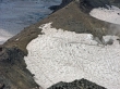
Climbers underneath Steamboat Prow on the Inter Glacier... which drains into Glacier Basin.
|
