Natapoc Mountain - 3.4.2010
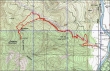
rodman's GPS route of our hike to Natapoc Mtn... 7.5 miles roundtrip, gaining 2343 feet of elevation.
|
From Coles Corner on Hwy 2... turn onto hwy South 207 and drive 3.6 miles... turn right onto Beaver Valley Road and drive 4.3. miles... turn right onto River Road and drive 1.5 miles... turn right onto a forest service road and park (1850') next to the power lines.
|
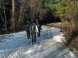
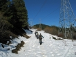
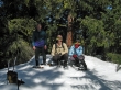
rodman, BarbE and madman on the icy forest service road.
|
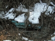
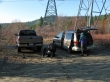
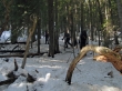
If this is your convertible, we found it in a creek.
|
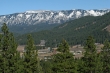
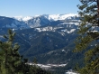
As we gained elevation on the forest service road, we could see the town of Plain... and over to Eniat Ridge.
|
Pretty much steady snow at ~2700 feet.
|
After hiking ~2.25 miles (3000')... we left the road after it crossed an obvious drainage... and then stayed on the north side of the drainage until we reached the ridge at ~4000 feet.
|
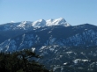
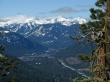
Big Jim Mtn on the left... and the Chiwaukum Mountains on the right.
|
A closeup of Big Jim Mountain.
|
A closeup of the Chiwaukum Mountains.
|
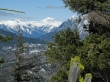
A closeup of Rock Mtn in the clouds on the left... then Mt. Howard and Mt. Mastiff.
|
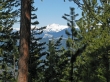
A closeup of Glacier Peak from the ridge leading to the Natapoc summit.
|
Three Fingered Jack and Mt. Maude from the ridge.
|
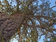
Ponderosa Pine on the treed summit (4204') of Natapoc Mtn.
|
The summit party... rodman and two Groucho Marx impersonators.
|
