Mutton Mountain - 3.18.2010
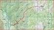
rodman's GPS route of our hike to Mutton Mtn... 9.7 miles roundtrip, gaining 3728 feet of elevation.
|
From Enumclaw, drive Hwy 410 towards Mt. Rainier... one mile beyond Buck Creek Campground turn left on FS 7170... drive less than a quarter-mile and park off the road at the Green Timbers sign.
|
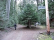
After walking FS 7170 for ~100 feet you reach the unofficial trailhead (2760').
|

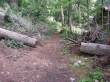
Follow along Deep Creek for a short distance...
|
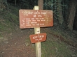
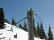
and find this sign for Deep Creek Trail #1196... this trail will take you to a ridge at 5900'.
|

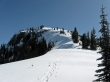
Hike in the trees until you reach the 5900 foot ridge.
|
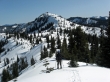
Mutton Mtn in the center of the photo... on the left, Mt. Baker to the Stuart Range... Rainier on the right.
|
Noble Knob (left foreground)... on the horizon left to right... Mt. Baker to the Stuart Range.
|
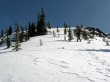
ragman getting ready to give back some elevation to get over to Mutton Mtn.
|
Only 200 feet of elevation left to reach the Mutton Mtn summit.
|
A frowning Gumby!
|
rodman nearing the Mutton Mtn summit.
|
Sweeping views from the Mutton Mtn summit (6156').
|
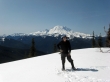
Little Tahoma and Mt. Rainier.
|
ragman on the Mutton Mtn summit.
|
