Mount Mellenthin (La Sal Mountains) - 6.6.2010
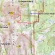
This is our approximate route to Mount Mellenthin and not a GPS route.
|
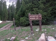
We parked at a hairpin turn (10,560') on the Dark Canyon Road... ~1 mile west of Dark Canyon Lake.
|
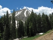
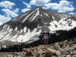
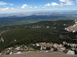
Mount Peale (12,721') from near our parking spot... the highest peak in the La Sal Mountains.
|
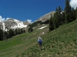
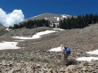
Denali Girl traversing towards the col between Mount Laurel (left) and Mount Mellenthin (right).
|
When we got a good look at the corniced col on the left, we decided to reverse course and head for the east end of Mellenthin.
|
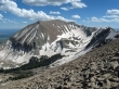
The north side of Mount Peale from ~11,200 feet on the south side of Mount Mellenthin.
|
We are going to avoid the cliffy south side of Mount Mellenthin by going to the east side (right).
|
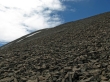
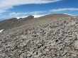
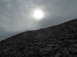
On the south side of Mellenthin now... above the cliffs... slow going on this pile of rubble.
|
Mount Peale from ~12,200 feet on the south side of Mount Mellenthin.
|
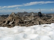
On the summit of Mount Mellenthin (12,645')... looking north across Geyser Pass to the northern peaks of the La Sal Range.
|
|
A pano shot... looking across Geyser Pass to the northern peaks of the La Sal Range.
|
Looking back at the Mellenthin summit as I head south to see if I can look down and see the col between Mellenthin and Laurel.
|
Mount Peale on the left... Mount Tukuhnikivatz on the right... Mount Laurel in the foreground.
|
Looking east as we head back to the car.
|
The weather is starting to change... this trip was ~5 miles roundtrip, gaining 2085 feet of elevation.
|
