Tokaloo Rock - 8.25.2010
rodman's GPS route of our bike and hike to Tokaloo Rock on the west side of Mt. Rainier... 16.2 miles roundtrip of biking, gaining 2500 feet of elevation... 10.75 miles roundtrip of hiking, gaining 4208 feet of elevation.
|
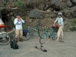
From the Nisqually entrance to Mt. Rainier National Park... drive ~1 mile and turn left onto the Westside Road... continue ~3 miles and park (2900') at the gate... put on dorky looking bike helmets and start pedaling.
|
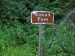
After 4 miles of biking reach Round Pass (4000').
|
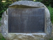
The Marine Memorial at Round Pass... in 1946, 32 marines died when their plane crashed into the Tahoma Glacier.
|
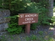
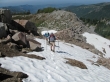
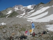
Give back 800 feet of elevation from Round Pass and then regain 600 of it back to the St. Andrews Creek trailhead (3800')... hide the bikes and start walking.
|
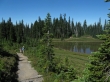
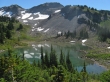
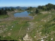
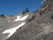
After 2.6 miles of hiking we arrived at Aurora Lake (5500') in Klapatche Park... and the Wonderland Trail.
|
rodman and BarbE leaving Aurora Lake... on the Wonderland Trail now and heading for St. Andrews Lake.
|
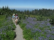
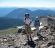
BarbE and rodman in a field of lupine above Aurora Lake.
|
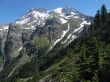
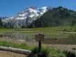
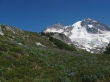
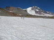
Mt. Rainier from the trail between Aurora Lake and St. Andrews Lake.
|
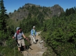
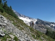
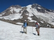
rodman and BarbE on the Wonderland Trail as we near St. Andrews Lake... Aurora Peak is behind.
|
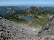
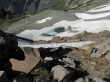
.8 miles from Aurora Lake we arrive at St. Andrews Lake... part of the Puyallup Cleaver is beyond the lake.
|
Still on the Wonderland Trail above St. Andrews Lake... just left of the lake you can see the boot path that does a good job in getting us started on our way to the Puyallup Cleaver.
|
Our general route from St. Andrews Lake up to the cleaver... and then on to Tokaloo Rock.
|
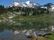
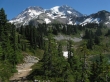
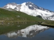
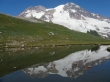
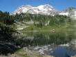
Mt. Rainier reflection on St. Andrews Lake.
|
Looking back on St. Andrews Lake as we head for the Puyallup Cleaver.
|
rodman and BarbE on the way to the Puyallup Cleaver.
|
Still winding our way up to the Puyallup Cleaver.
|

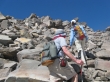
BarbE and rodman climbing.
|
Getting higher above St. Andrews Lake.
|
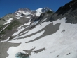
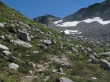
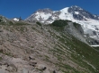
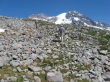
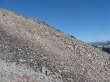
The north side of the Puyallup Cleaver is very steep... we will find easier terrain on the south side.
|
BarbE and rodman on the Puyallup Cleaver.
|
We will bypass this one-of-many high points on the cleaver by using a faint boot path along the south side (right).
|
rodman and BarbE on the faint boot path leading around one of the cleaver high points... the high point of Glacier Island is prominent to the right.
|
rodman continuing on faint path along the south side of the Puyallup Cleaver.
|
Still on the south side of the Puyallup Cleaver... Tokaloo Rock and Tokaloo Spire in the distance on the left.
|
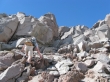
One of several tarns along the Puyallup Cleaver.
|
rodman and BarbE... still climbing.
|
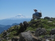
BarbE reflects on whether or not she will ever hike with insane people again... Mt. Adams in the distance.
|
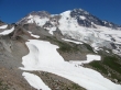
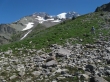
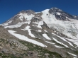
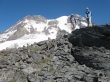
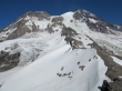
A nice look at the upper part of the Puyallup Cleaver as it separates the Puyallup Glacier (left) from the Tahoma Glacier (right).
|
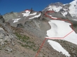
Our general route to Tokaloo Rock.
|
ragman and BarbE on the Puyallup Cleaver... it finally seems like we are getting closer to Tokaloo Rock.
|
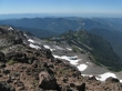
Looking down on St. Andrews Lake and Aurora Peak from the Puyallup Cleaver.
|
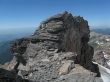
Tokaloo Sipre is hiding the summit of Tokaloo Rock.
|
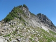
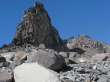
St. Andrews Rock (10,992') is the high point on the Puyallup Cleaver.
|
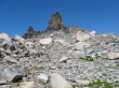
The Tokaloo Rock summit is the dark pile of rocks just to the right of Tokaloo Spire.
|
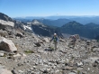
BarbE and rodman ascending... Glacier Island and Pyramid Peak are in the foreground... Goat Rocks (left) and Mt. Adams are on the horizon.
|
BarbE and ragman have almost reached the Tokaloo Spire.
|
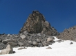
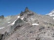
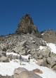
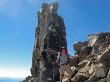
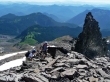
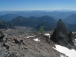
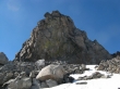
Tokaloo Spire (7480+).
|
BarbE and rodman near Tokaloo Spire.
|
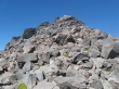
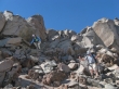
Still some scrambling to do in order to reach the summit of Tokaloo Rock.
|
Looks like rodman is ready to be devoured by Tokaloo Spire.
|
rodman scrambling on Tokaloo Rock.
|
rodman still scrambling on Tokaloo Rock.
|
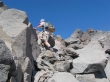
Still a couple hundred feet below the summit... but which bump is the summit?
|
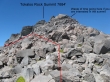
The red line and dots show the route to the Tokaloo Rock summit... of course we didn't know this at the time... so we wasted some time in going to the closest bump.
|
BarbE keeps the huge boulder from rolling onto rodman.
|
ragman and rodman trying to catch up with BarbE as we near what we assume is the summit.
|
Oops... that is the summit and there is no way we are going to try and get there from where we are...
|
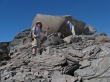
rodman and BarbE on the Tokaloo Rock summit (7684')... we found an easy Class 2 route on the NW side of the summit block.
|
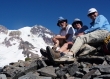
Group shot on the Tokaloo Rock summit.
|
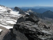
Glacier Island and Pyramid Peak in the foreground... then part of the Tatoosh Range... then Goat Rocks and Mt. Adams on the horizon.
|
Tokaloo Spire from the Tokaloo Rock summit... Mt. Adams and Mt. St. Helens on the horizon.
|
Mt. Rainier and the upper part of the Puyallup Cleaver from Tokaloo Rock.
|
After 30 minutes on the summit it is 3:30 p.m. and time to head down.
|
Passing by Tokaloo Spire.
|
Looking back on the Tokaloo Rock summit.
|
Tokaloo Spire as we head down.
|
We are all so very very small.
|
rodman and BarbE do some boot-skiing to save some time on the way down.
|

Glacier Island and Pyramid Peak.
|
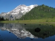
Rainier reflection.
|
We are almost back to St. Andrews Lake... and will pump some water at the tarn below.
|
rodman pumps water while BarbE keeps the mosquitos off of his back.
|
It is 5:45 p.m. and we are back at St. Andrews Lake.
|
It is 6:05 p.m. and we are back at Aurora Lake... the rocks in the lake look like holes have been burned into the photo... it will take 40 minutes to do the 2.6 miles back to the bikes... and after a 1.5 hour bike ride we will get back to the car at 8:30 p.m... whew!
|
