Rock Mountain - 4.22.2011

8.2 miles east of Stevens Pass on US-2... look for the brown Rock Mtn sign on the north side of the road... the trailhead (~2700') is less than 100 feet from the highway.
|
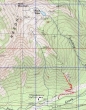
rodman's GPS route of our failed attempt on Rock Mountain... 2.5 miles roundtrip, gaining 1466 feet of elevation... unstable snow conditions on steep terrain made for an easy decision to retreat.
|
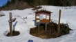
The Rock Mountain trailhead is only about 100 feet from US-2.
|
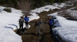
Izzy (4 legs), Snowdog, Denali Girl, rodman and BarbE are ready to go.
|
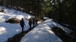
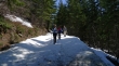
The first half mile is on gentle terrain and melted out.
|
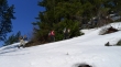
The terrain steepens dramatically after the first half mile.
|
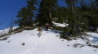
Ever upward... still carrying our snowshoes... but the snow is getting deeper and softer.
|
ragman in his rightful place... US-2 a thousand feet below.
|
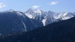
Looking at Arrowhead Mountain across the highway... it would have been the better choice today.
|
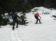
Izzy keeps an eye on rodman... we've gone to snowshoes at ~3700 feet.
|
Looking across the highway at the Chiwaukum Mountains.
|
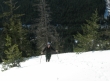
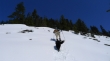
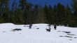
Snowdog on steep terrain.
|
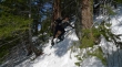
ragman, Snowdog and BarbE working hard.
|
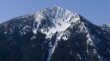
We are retreating now... it was 11:45 a.m. and it had taken us two hours to gain the last 1000 feet of elevation to 4200 feet... and with the summit at 6852', it didn't take a rocket scientist to figure out that we would not stand on top of Rock Mtn today.
|
Almost back to the car now... maybe we should head for Gustav's in Leavenworth for refreshments... we've earned it!
|
