Manatee Peak (a.k.a. Foss Peak) - 5.10.2011
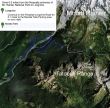
Drive 6.5 miles from the Nisqually entrance of MRNP to Longmire... then drive 8.1 miles from Longmire to the Narada Falls parking area.
|
rodman's GPS route of our snowshoe trip to the Manatee Peak (a.k.a. Foss Peak) summit... 7.25 miles roundtrip... gaining 2645 feet of elevation.
|
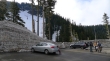
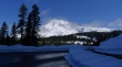
The Narada Falls parking area (4600') in Mount Rainier Nat. Park... BarbE talking with two guys from North Carolina.
|
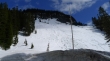
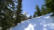
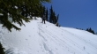
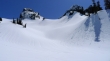
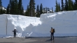
The 200 foot embankment that leads up to the Stevens Canyon Road.
|
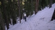
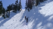
rodman in the woods... climbing up the 200 foot embankment.
|
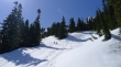
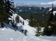
We've reached the Stevens Canyon Road (4840') at the top of the embankment... and a pretty nice view of Mt. Rainier.
|
BarbE and the North Carolina guys rounding a corner of the Stevens Canyon Road.
|
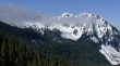
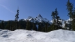
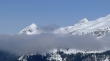
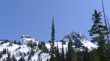
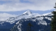
Eagle Peak (center)... Chutla Peak in the clouds.
|
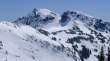
The Castle (left) and Pinnacle Peak from the Stevens Canyon Road.
|
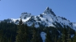
A closeup of The Castle and Pinnacle Peak.
|
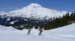
BarbE leaves the road (4900')... puts on snowshoes... and starts up... Pinnacle Peak in the distance.
|
Pete and Jason... visiting from North Carolina.
|
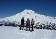
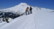
BarbE and rodman... Pinnacle Peak above.
|
BarbE and rodman continuing up.
|
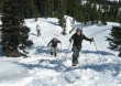
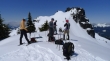
Jason, Pete and ragman heading up.
|
rodman and BarbE... barely see the top of Pinnacle Peak.
|
BarbE and rodman traversing towards a really nice view spot.
|
Jason, Pete, ragman and rodman nearing the view spot.
|
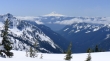
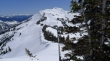
Mt. Rainier... Reflection Lakes at the bottom of the photo... Pyramid Peak and Glacier Island on the left.
|
A closeup of Pyramid Peak (left) and Glacier Island.
|
The Castle (left) and Pinnacle Peak... we are heading for the ridge on the left side of The Castle.
|
Pete, Jason, rodman and BarbE heading for the ridge on the east side of The Castle.
|
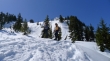
Ever upward.
|
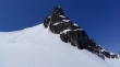
The east side of The Castle.
|
BarbE leading the way to the ridge.
|
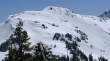
We've reached the ridge (6200')... and can now see the south side of The Castle.
|
Looking south to Mt. Adams.
|
Looking south to Mt. St. Helens.
|
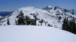
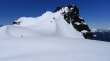
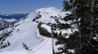
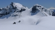
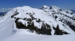
Manatee Peak (left), Unicorn Peak and Boundary Peak.
|
A closeup of Unicorn Peak (left) and Boundary Peak.
|
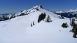
A closeup of Manatee Peak (a.k.a. Foss Peak).
|
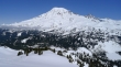
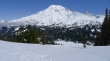
Mount Rainier... with Louise Lake in the lower right corner.
|
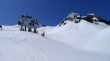
Everyone is getting their camera ready for a photo shoot.
|
ragman, rodman and BarbE... on the ridge east of The Castle... with that white thing behind us.
|
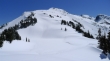
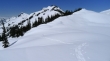
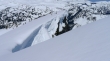
Looking down on the corniced ridge leading over to Manatee Peak.
|
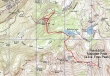
Our general route to the Manatee Peak summit.
|
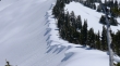
A closeup of the corniced ridge between The Castle and Manatee Peak.
|
We will give back 250 feet of elevation on our way to Manatee Peak.
|
BarbE and rodman on the corniced ridge.
|
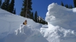
BarbE has her way to deal with these bumps...
|
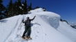
and rodman has his way of dealing with the bumps.
|
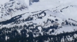
Looking back on the corniced ridge as we near the small pond (5960').
|
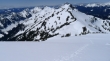
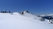
Manatee Peak from the small pond.
|
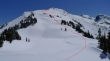
Our general route from the small pond to the Manatee Peak summit.
|
On our way to the summit now... looking back on The Castle... Plummer Peak is left of The Castle.
|
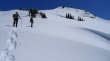
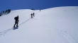
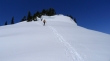
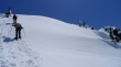
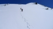
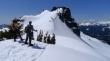
rodman and BarbE heading up.
|
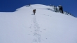
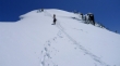
Still heading up.
|
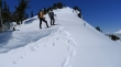
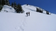
Getting closer.
|
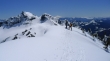
Getting really close now... stay away from the cornices on the left.
|
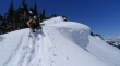
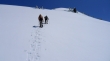
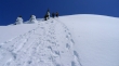
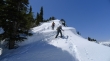
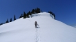
The final push to the Manatee Peak summit.
|
rodman and BarbE on the Manatee Peak summit (6524')... Unicorn Peak (left) and Boundary Peak with Mt. Adams and Mt. Hood in the distance.
|
A closeup of Unicorn Peak, Boundary Peak and Mt. Adams.
|
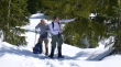
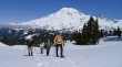
BarbE and rodman on the summit.
|
ragman on the summit.
|
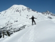
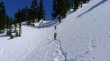
Heading down now... plunge-stepping instead of using our snowshoes.
|
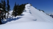
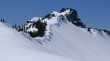
The east side of Manatee Peak is very sheer.
|
Descending.
|
Looking at our route back to The Castle.
|
Getting closer to the small pond.
|
Working our way above the small pond.
|
From the small pond... looking at our route back to The Castle.
|
Corniced ridge and The Castle.
|
A closeup of the corniced ridge leading to The Castle.
|
BarbE and rodman heading up the corniced ridge.
|
Still heading up.
|
Looking back on Manatee Peak, Unicorn Peak and Boundary Peak.
|
All downhill from here... last look at the south side of The Castle.
|
A closeup of Paradise.
|
BarbE and rodman looking at me... or maybe looking at The Castle.
|
Last good look of The Castle and Pinnacle Peak as we head down.
|
rodman and BarbE descending.
|
I like the tree in the middle of the photo.
|
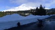
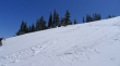
Back down to the Stevens Canyon Road... wow, there is a ton of snow.
|
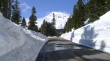
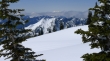
Walking the road back to Narada Falls... very easy on the eyes.
|
A closeup of Pyramid Peak... less than a half-mile to get back to the car.
|
