Paulina Peak - 9.26.2011
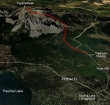
Paulina Peak is located in the Newberry National Volcanic Monument near Sunriver, Oregon... the hike is 5 miles round trip, gaining 1650 feet of elevation.
|

Drive Hwy 97 south from Sunriver, Oregon for 8.8 miles to the turnoff for Paulina Lake... then drive 10.9 miles to the entrance to the Newberry Nat Volcanic Monument.
|
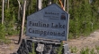
Reach the Paulina Lake Campground after driving 1.6 miles from the monument entrance.
|
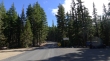
From the Paulina Lake Campground, drive Road 500 for .6 miles to this parking area... the unsigned trailhead (~6350 feet) is located between the fence posts on the left side of the road.
|
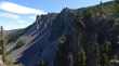
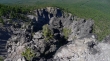
After a mile of hiking you start to get views of the rock outcroppings on the north end of Paulina Peak.
|
Rock outcroppings along the trail... with Paulina Lake (left) and East Lake.
|
The higher we got, the better view we got of Paulina Lake.
|
Getting higher... the summit is the little bump on the far right.
|
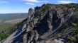
Looking down on some of the rock outcroppings as we continue up.
|
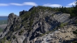
We will go over and take a closer look at the rock outcroppings.
|
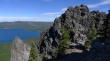
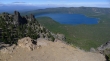
Paulina Lake and rock outcroppings on Paulina Peak.
|
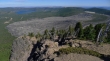
We can see the fenced parking area at the Paulina Peak Overlook.
|
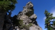
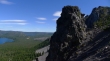
Rock formation.
|
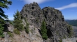
More rock formations.
|
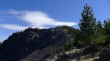
Getting close to the summit area now.
|
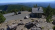
Looking south from the Paulina Peak summit (7984')... if you don't want to hike to the summit, just drive Road 500 to the top.
|
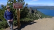
Denali Girl on the Paulina Peak summit.
|
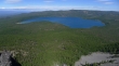
Paulina Lake from the Paulina Peak summit.
|
Pano shot showing Paulina Lake (left), East Lake and an obsidian flow.
|
A closer look at East Lake and the obsidian flow.
|
