Judy Peak and Mary Peak - 5.29.2012
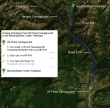
Google map directions from 29 Pines Campground to the Beverly/Bean Creek Trailhead.
|
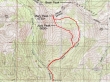
rodman's GPS route of our trip to Judy Peak and Mary Peak... 6.1 miles roundtrip, gaining ~3200 feet of elevation.
|
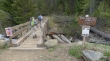
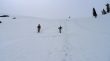
Starting from the Beverly/Bean trailhead (3610')
|
A half mile up the trail we turned right and and headed for Bean Creek Basin.
|
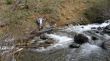
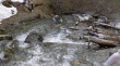
larman charged across the creek crossing... he carried a spare pair of socks, but didn't need them.
|
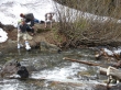
larman got this shot of rodman starting to cross in his garbage bags... ragman and rocman are going to cross in sandals.
|
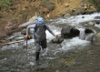
rodman... almost to his knee on this step... but he stayed dry.
|
With sandals on, rocman can take his time to find the best foot placements.
|
ragman had the advantage of watching everyone else cross before him.
|
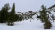
Immediately after crossing the second gully, we left the trail and headed up (~4800').
|
Steeper than it looks here.
|
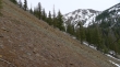
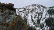
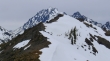
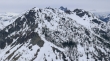
Looking over at Earl Peak gives a better idea of the steepness of the terrain.
|
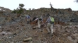
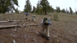
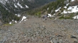
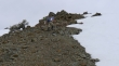
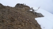
After gaining a few hundred feet of elevation it started to get more rocky.
|
Still heading up.
|
Using our hands in places.
|
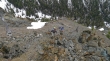
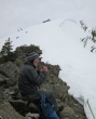
larman leading us over to a nice spot to take a break.
|
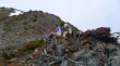
rodman, larman and rocman at our break spot.
|
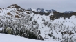
Earl Peak from our break spot.
|
Looking down to Bean Creek from our break spot.
|
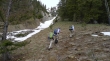
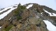
Leaving our break spot.
|
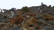
Continuing up.
|
Continuing up.
|
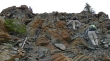
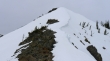
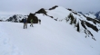
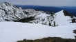
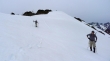
Looks like the terrain will be easier very soon.
|
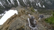
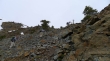
Still gaining elevation.
|
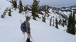
Are we having fun yet?
|
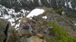
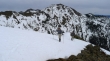
Almost off of the rock now.
|
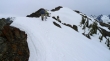
Only had to cross one short finger of snow... Earl Peak in the distance.
|
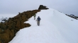
Much easier terrain now... so close to the ridge.
|
Almost to the ridge (~6200').
|
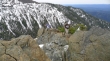
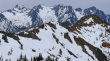
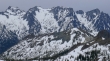
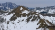
A pano of Judy Peak (left foreground)... then Mary Peak, an unnamed bump, Bean Peak and Earl Peak on the far right... with part of the Stuart Range in the distance.
|
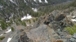
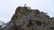
rodman got this shot of ragman bundled up at our rest spot when we reached the ridge.
|
Bean Peak (left foreground)... Colchuck, Dragontail, Little Annapurna and McClellan in the distance.
|
rodman and larman heading up toward Judy now... Earl Peak across the valley.
|
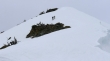
rodman and larman are specks in the center of the photo... the Judy summit is above.
|
larman and rodman have one last pull to reach the Judy summit.
|
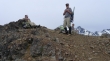
rocman nears the Judy Peak summit (6600+).
|
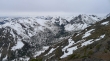
From the Judy summit we can see the ridge that will get us over to Mary... Mt. Daniel and Bill Peak are left of the ridge... Bean Peak (right foreground)... the Stuart Range beyond.
|
Looking down at the Beverly Creek drainage... Iron Peak on the other side of the valley... Teanaway Peak and Bill Peak at the head of the valley.
|
A closer look at the ridge leading to Mary Peak... with Mt. Stuart and Sherpa Peak beyond.
|
Bean Peak in the right foreground... with Colchuck, Dragontail and Little Annapurna in the distance.
|
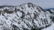
Looking across Bean Creek Basin to Earl Peak.
|
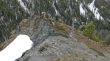
There are a few ups and downs along the ridge from Judy to Mary.
|
rodman and larman heading for the Mary summit, but the summit isn't in the photo.
|
larman, rodman and rocman at a false summit.
|
Now we can see the true Mary summit.
|
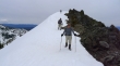
Getting closer.
|
Reaching the Mary summit.
|
On the Mary summit now... looking back at the ridge we followed to Judy Peak and then to Mary.
|
Two Dawgs and an Englishman on the Mary Peak summit (6730').
|
The Stuart Range from the Mary Peak summit... foreground peaks are Devils Head, Volcanic Neck and Bean Peak.
|
Colchuck, Dragontail and Little Annapurna... with Devils Head and Volcanic Neck in the foreground.
|
The ridge leading from Mary Peak over to Bean Peak... McClellan Peak in the distance on the left.
|
Looking across Bill Peak to Fortune Peak and Ingalls Peak... with Mt. Daniel in the distance on the far left.
|
Leaving the Mary Peak summit and looking for the best way to get down to the Bean Creek Basin.
|
larman studies the terrain... Bean Peak in the distance.
|
Plunge stepping down from the Judy/Mary ridge.
|
Bean Peak from the basin.
|
Earl Peak from the basin.
|
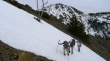
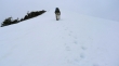
From the basin we followed tracks in the snow back to the second gully... tons of Glacier Lilies on this hike.
|
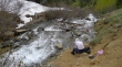
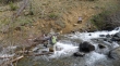
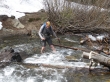
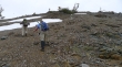
Back at the stream crossing... how will rodman do this time... get around that rock...
|
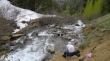
now between the big rock and that log... looking for higher ground now.
|
found the higher ground... now looking for rocks near the surface of the creek.
|
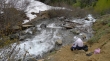
still looking good... almost across...
|
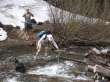
oh darn... found that hole again... but still stayed dry.
|
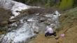
ragman chose the 'bull rush' approach... wet feet at the end of the day wouldn't be a problem... .75 miles left to get back to the car.
|
