Three Musketeers Ridge - 7.4.2012
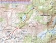
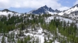
The approximate route from our campsite in the Upper Enchantments to our high point on Three Musketeers Ridge... ~8 miles roundtrip, gaining ~2340 feet of elevation.
|
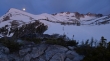
After spending most of Tuesday in the tent, I woke up at 4:50 a.m. on July 4th to this view of the moon over Little Annapurna.
|
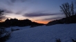
Looking to the east I saw this... and quickly put my boots on and hustled for higher ground.
|
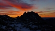
At 5:07 a.m. I got this shot of the sunrise behind Prusik Peak... the best 4th of July fireworks show I could ask for.
|
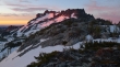
Sunrise hitting McClellan Peak.
|
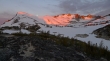
Sunrise hitting Little Annapurna and Dragontail Peak... with a bonus moon.
|
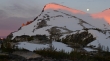
A closeup of the sunrise and moonset on Little Annapurna.
|
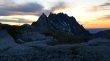
Prusik Peak at 5:25 a.m... most of the red color is gone now.
|
The morning sunshine has brought out mother and baby.
|
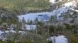
Snowdog and BarbE enjoy the sunny morning from our camp (7440')... McClellan Peak behind.
|
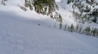
The goats are prowling... looking through the gap to Navaho Peak in the Teanaway... Mt. Rainier in the distance on the far right.
|
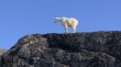
One of our campsite guardians.
|
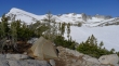
A pretty nice view from my tent site.
|
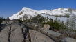
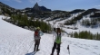
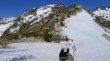
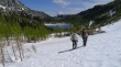
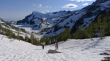
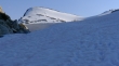
Snowdog and BarbE put on their crampons to prepare for the day's journey.
|
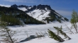
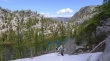
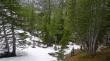
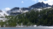
Descending toward Inspiration Lake... with Little Annapurna behind.
|
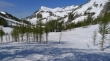
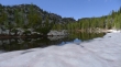
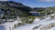
Inspiration Lake... Prusik Peak and The Temple in the distance.
|
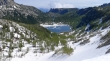
Above Perfection Lake now... we will be heading for Prusik Pass... the low point on the ridge left of Prusik Peak.
|
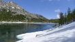
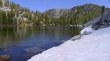
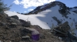
At Perfection Lake (7100')... McClellan Peak in the distance.
|
Gaining elevation now toward Prusik Pass... looking back on Perfection Lake, Little Annapurna and part of Dragontail Peak.
|
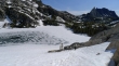
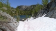
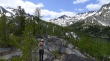
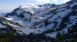
At Prusik Pass now (7500')... looking down on Shield Lake and Earle Lake... and out to Edward Mesa... with 'The Mole' at the left end of Edward Mesa.
|
Still in the Prusik Pass area... BarbE walking over toward Prusik Peak to try and find the best route down to the lakes.
|
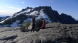
BarbE and Snowdog discussing options... Enchantment Peak is above.
|
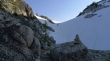
I've started to descend from Prusik Pass on exposed rock and dirt... looking up at Prusik Pass now.
|
Here comes BarbE and Snowdog.
|
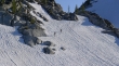
After running out of rock and dirt, BarbE and Snowdog glissade the rest of the way down to the basin.
|
Heading for Shield Lake... still a couple hundred feet above the lake.
|
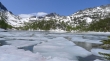
At the south end of Shield Lake.
|
Going along the east side of Shield Lake.
|
At the north end of Shield Lake... looking back on Prusik Pass and Enchantment Peak.
|
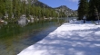
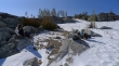
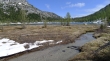
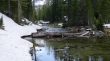
Almost to Earle Lake now... looking at the very wide stream that connects Shield and Earle.
|
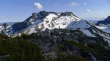
Past Earle Lake now and dropping down to Mesa Lake... Edward Mesa in the distance.
|
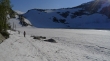
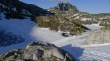
Looks like we are going to get cliffed-out at Mesa Lake.
|
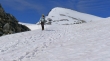
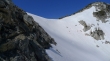
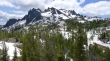
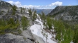
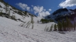
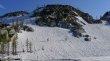
Ascending from Mesa Lake now... on the western end of Three Musketeers Ridge now.
|
Ascending Three Musketeers Ridge now... looking back toward Prusik Pass... The Temple on the left... Enchantment Peak in the center... with Cannon Mountain somewhere high on the right.
|
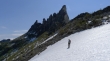
We can see two of the Musketeers now... with the third being hidden by the two on the left... but can we get there??
|
The north side of The Temple from Three Musketeers Ridge.
|
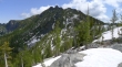
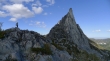
Enchantment Peak from Three Musketeers Ridge.
|
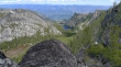
Edward Mesa from Three Musketeers Ridge.
|
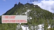
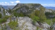
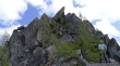
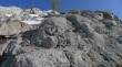
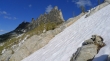
Three Musketeers Ridge is a very gnarly ridge... huge boulders and lots of menacing trees... and I think that I have labeled things correctly.
|
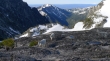
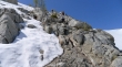
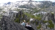
BarbE and Snowdog working their way along Three Musketeers Ridge... Edward Mesa on the right.
|
|
A pano shot from Three Musketeers Ridge... The Temple (left), Enchantment Peak and Cannon Mountain.
|
We have reached what is going to turn out to be our high point... BarbE looks for a route... looks like it would be fairly easy to get up to the high tree just below the leaning rock... but then what?
|
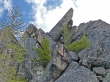
ragman is past the high tree and just below the leaning rock... and has found a chimney.
|
BarbE and Snowdog come up to the high tree.
|
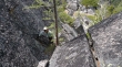
I have climbed up the chimney... and looking down to Snowdog and BarbE.
|
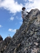
BarbE got this photo of ragman on our high point (~7500 feet).
|
Looking down on Toketie Flats (lower left)... Toketie Lake (center)... and Leavenworth in the distance.
|
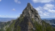
The western Musketeer... which is blocking the middle and eastern musketeers.
|
BarbE and Snowdog hanging out just above the chimney.
|
We found an easier route on the way down that allowed us to get off of the ridge sooner and save some ground by skipping Mesa Lake altogether.
|
Back at Earle Lake.
|
Almost back to Shield Lake.
|
The north end of Shield Lake... looking up to Prusik Pass and Enchantment Peak.
|
A closeup of Prusik Pass (left) and Enchantment Peak.
|
Snowdog and BarbE lead the charge toward Prusik Pass.
|
Looking back on Shield Lake as we hike back up toward Prusik Pass.
|
Back on rock and dirt now.
|
Prusik Peak.
|
Almost back to Prusik Pass.
|
From Prusik Pass we decided to take a short side trip... gaining another 100 feet of elevation for this view of McClellan Peak.
|
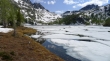
Looking at Perfection Lake (left) and Inspiration Lake... with Little Annapurna and Dragontail Peak above.
|
BarbE and Prusik Peak.
|
Looking down on Lake Viviane.
|
Snowdog and BarbE leaving Prusik Pass and heading down to Perfection Lake.
|
Walking around Inspiration Lake on the way back to camp.
|
BarbE and Snowdog above Inspiration Lake... our camp is on the other side of the rocks above.
|
Still gaining elevation back to camp.
|
Looking back at Inspiration Lake (left), Perfection Lake (right)... with Prusik Peak and The Temple in the distance.
|
Still gaining elevation.
|
Camp is just around the corner on the left... Little Annapurna is above... an up and down, tiring day of hiking.
|
