Snoqualmie Mountain (East summit) - 7.12.2012
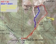
I altered rodman's GPS route from 2010 to show our approximate route to the east summit of Snoqualmie Mountain... ~4.5 miles roundtrip, gaining ~3200 feet of elevation.
|
Park in the Alpental Ski Area parking lot... cross the road and start hiking on the unsigned path... do not start on the Snow Lake Trail.
|
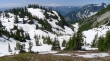
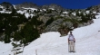
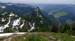
Denny Mountain from the Alpental parking lot.
|
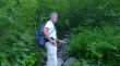
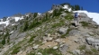
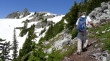
larman is on the overgrown path to Snoqualmie Mountain and Guye Peak.
|
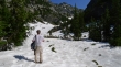
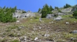
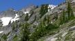
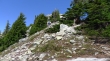
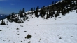
At ~4000 feet we found the huge boulder field... and continued up and to the left for Snoqualmie Mountain.
|
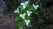
Trillium.
|
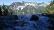
The only stream crossing is at ~4200 feet.
|
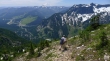
At ~4350 feet we took a very short side trip over to the stream and got this look across the valley to Denny Mountain, The Tooth and Bryant Peak.
|
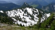
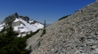
We have reached the drainage that runs between Snoqualmie Mountain (left) and Cave Ridge (right).
|
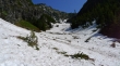
We will follow the Snoqualmie/Cave drainage around until it starts to drop down into Commonwealth Basin.
|
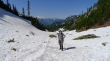
larman got this shot of me in the Snoqualmie/Cave drainage... Mt. Rainier in the distance.
|
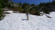
larman is leaving the Snoqualmie/Cave drainage and heading for the ridge that runs south from Point 6160+.
|
Off the snow now and heading for the ridge south of Point 6160+.
|
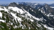
Gaining elevation and looking back on Cave Ridge (left), the Snoqualmie/Cave drainage (center) and Denny Mountain (right)... with Mt. Rainier in the distance.
|
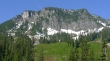
A closeup of Red Mountain.
|
larman heading up on the ridge south of Point 6160+... the east summit of Snoqualmie Mountain is the high point on the left.
|
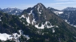
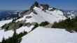
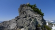
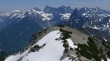
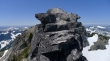
A closer look at the east summit of Snoqualmie Mountain.
|
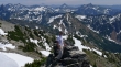
Looking down on Cave Ridge and Guye Peak... Keechelus Lake is above left... Snoqualmie Pass and the ski area are above right.
|
larman continuing toward Point 6160+.
|
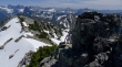
We are heading for Point 6160+ (the pile of rubble on the far right)... with the east summit of Snoqualmie Mountain on the far left.
|
Lundin Peak (left foreground) and Red Mountain (right foreground).
|
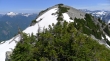
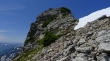
As we get closer to Point 6160+, the east summit of Snoqualmie Mountain takes on more of a knife-edge look.
|
Still ascending toward Point 6160+.
|
larman is traversing underneath Point 6160+ and will follow the ridge over to the east summit of Snoqualmie Mountain... the true summit is just to the right of the east summit.
|
I'm following larman's steps along the ridge... a couple of ups and downs along the route.
|
The east summit is up there somewhere.
|
Looking back at Point 6160+... Big Snow Mountain on the left... Chikamin Peak, Four Brothers and Mt. Stuart on the right.
|
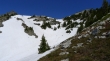
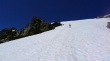
One more snow field to deal with and we will be ready to climb up to the east summit.
|
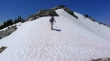
larman is on the last snow field.
|
Heading for the east summit and looking for a lunch spot... the true summit is on the right.
|
larman has found a good lunch spot... east summit is above.
|
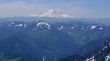
A closeup of Mt. Rainier on this hazy day.
|
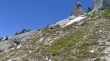
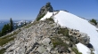
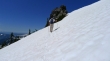
The final stretch to the east summit is Class 2.
|

I'm climbing and looking down on larman... Point 6160+ is in the left foreground.
|
larman is coming up.
|
larman is almost on the summit... Point 6160+ is on the left.
|
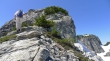
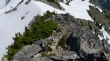
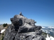
I'm on the east summit and looking over at two people on the true summit.
|
Another look at the true summit from the east summit... Granite Mountain in the distance on the left... Mt. Roosevelt and Preacher Mountain in the distance on the right.
|
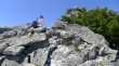
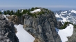
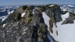
larman got this shot of me snapping photos from the east summit (6240+).
|
Looking across Point 6160+ to Hinman, Overcoat, Chimney Rock, Lemah, Thomson, Chikamin and others.
|
larman at the summit area with Red Mountain behind him... some of the other peaks are Thomson, Chikamin, Four Brothers, Stuart, Three Queens, Alta and Hibox.
|
Looking back at the east summit as we head down.
|
larman coming down from the east summit.
|
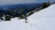
We will take a more direct route down... using the snowfields on the south side of the mountain to get back over to the main route.
|
We will drop down into the small basin below and find the main trail on the rib running from the upper right of the photo to the center of the photo.
|
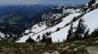
Heading for the small basin below.
|
larman near the small basin on the south side of Snoqualmie Mountain... with the east summit above center.
|
In the small basin now... the main trail is on the rib beyond.
|
We have found the main trail and will close the loop portion of our trip several hundred below.
|
Cave Ridge (left) and Guye Peak... with Keechelus Lake and the Snoqualmie Pass ski area beyond... we will still need to lose at least 2000 feet of steep elevation to get back to the car.
|
