Echo Rock and Observation Rock - 7.21.2012
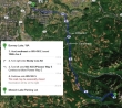
Google map instructions on how to get to the trailhead at Mowich Lake.
|
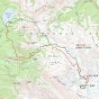
rodman's GPS route from 2008... the same that BarbE and I took this time... 13 miles roundtrip, gaining 4349 feet of elevation.
|
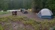
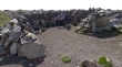
The walk-in campground at Mowich Lake.
|
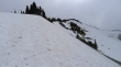
We are heading for Spray Park.
|
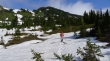
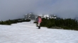
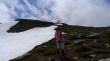
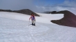
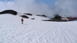
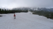
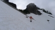
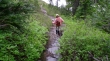
BarbE on the way to Spray Park.
|
|
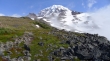
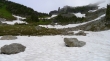
We have hiked 3 miles to lower Spray Park... Hessong Rock (left) and Mt. Pleasant.
|
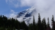
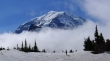
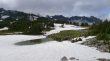
Mt. Rainier is barely visible from lower Spray Park.
|
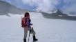
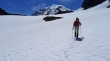
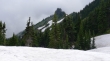
BarbE continues up Spray Park... Mt. Pleasant above.
|
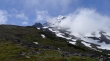
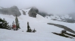
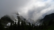
Looks like the clouds will disappear.
|
Mt. Rainier from upper Spray Park.
|
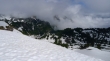
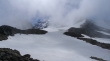
Looking down on Seattle Park from upper Spray Park... Mother Mountain in the clouds.
|
Doing the best we can to follow the Wonderland Trail... Mt. Pleasant and Mother Mountain in the distance.
|
BarbE continues on the Wonderland Trail.
|
Off of the Wonderland Trail now and heading toward Echo Rock, Mt. Rainier and Observation Rock on a good path.
|
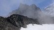
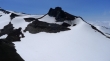
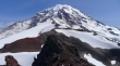
Echo Rock is left of Mt. Rainier... Observation Rock is in the clouds.
|
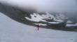
BarbE in the clouds... Observation Rock on the right.
|
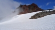
Mt. Rainier is barely visible... Echo and Observation are in the clouds.
|
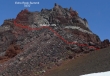
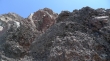
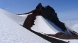
A closeup of Echo Rock.
|
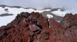
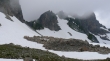
At the foot of the Flett Glacier... and now the clouds are gone.
|
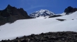
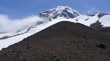
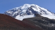
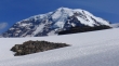
Mt. Rainier from the foot of the Flett Glacier.
|
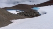
Melt pools at the foot of the Flett Glacier.
|
BarbE on the Flett Glacier... we have left the clouds behind.
|
BarbE on the Flett Glacier between Echo Rock and Observation Rock.
|
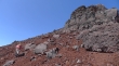
Heading for that easy looking ridge (far right) on the south side of Echo Rock.
|
BarbE eyes the target.
|
From the south ridge we will work our way up to the base of the cliffs... then follow the cliffs around to the north side of the summit block... then come back to the south side for the easiest route to the summit.
|
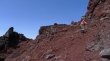
An obvious path leads from the glacier up to the south ridge.
|
Looking along Echo's south ridge to Mt. Rainier.
|
Time to work our way up to the base of the cliffs.
|
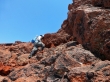
BarbE heading for the base of the cliffs.
|
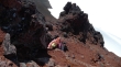
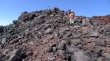
At the base of the cliffs and looking up.
|
BarbE underneath the cliffs and working around toward the north side of Echo Rock.
|
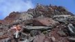
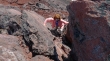
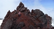
The first of two Class 2+ moves on the north side of Echo Rock.
|
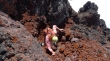
The second Class 2+ move on the north side of Echo Rock.
|
ragman on the north side of Echo Rock.
|
BarbE on the north side of Echo Rock.
|
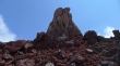
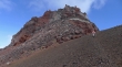
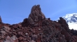
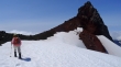
The summit block of Echo Rock.
|
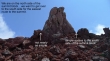
From the north side of the summit block, the easiest way to go is to the right.
|
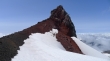
BarbE is underneath the summit... coming from the north side of the summit block over to the south side.
|
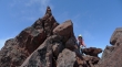
ragman on the south side of the summit and heading up.
|
Look ma... no hands.
|
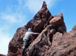
BarbE starting up for the summit.
|
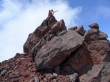
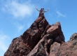
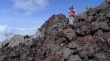
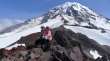
BarbE on the Echo Rock summit (7870').
|
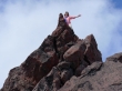
BarbE can fly.
|
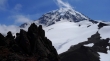
Mt. Rainier from the Echo Rock summit area.
|
Observation Rock from Echo Rock... heading over there next.
|
BarbE having lunch at the Echo Rock summit area.
|
Leaving the Echo Rock summit area.
|
Back down to the easy south ridge of Echo Rock.
|
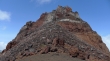
Echo Rock in the distance as we work our way along the south ridge over toward Observation Rock.
|
Looking back at Echo Rock as we start to head up toward Observation Rock.
|
Looking back as we head up toward Observation Rock.
|
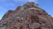
BarbE and Observation Rock... summit is on the right.
|
On steeper terrain now as we head for Observation Rock.
|
Mount Rainier from the south side of Observation Rock.
|
BarbE on the south side of Observation Rock.
|
The south side of Observation Rock... look closely for the path leading over to the west side.
|
BarbE on the west side of Observation Rock... on very easy terrain now.
|
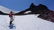
BarbE nearing the Observation Rock summit (8364').
|
ragman and BarbE on the Observation Rock summit.
|
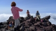
We met two nwhiker lurkers on the Observation summit... lots of clouds to the north.
|
Mt. Rainier from the Observation Rock summit... time to head down.
|
BarbE on the Flett Glacier and heading back toward Spray Park.
|
Clouds swirl around Echo Rock.
|
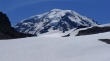
Mt. Rainier as we head down the Flett Glacier.
|
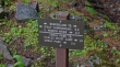
We found a very cool campsite... chair with back rest, a table for cooking and a great wind break.
|
BarbE leaving the campsite we found.
|
Heading down.
|
Looking back as we head down for the clouds in Spray Park.
|
As we near Spray Park the clouds are going to take away the Rainier views.
|
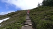
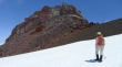
BarbE heading for Spray Park.
|
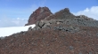
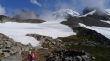
Back at upper Spray Park... we will go up and over the east ridge (left) of Mt. Pleasant and head for Knapsack Pass... Mother Mountain on the right.
|
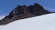
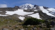
Hessong Rock as we near the east ridge of Mt. Pleasant.
|
From the east ridge of Mt. Pleasant we are looking up at the Mt. Pleasant summit.
|
BarbE heads down from the east ridge of Mt. Pleasant... Knapsack Pass is somewhere over there on the right.
|
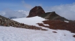
Knapsack Pass is in the center of the photo.
|
Knapsack Pass on the left.
|
BarbE heading for Knapsack Pass.
|
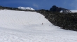
Off of the snow now and heading for Knapsack Pass.
|
At Knapsack Pass (6200') now... only a 1.5 mile hike down to Mowich Lake which is somewhere down there in the clouds.
|
BarbE coming down from Knapsack Pass.
|
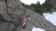
Snow melt has taken over this part of the unmaintained trail from Mowich Lake to Knapsack Pass.
|
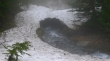
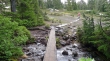
We decided not to use this snow bridge.
|
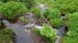
Is the trail a creek... or is the creek a trail?
|
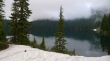
Finally... we have arrived at Mowich Lake... only a 5 minute walk to the car... a very long day.
|
