Kuna Peak, Koip Peak and Mount Lewis - 8.15.2012
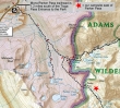
Starting from the Mono/Parker Pass trailhead (9700') we backpacked to Parker Pass (11,100') and camped a quarter mile at some tarns on the east side of the pass... a hike of 5.5 miles, gaining ~1500 feet of elevation.
|
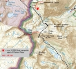
On day two we hiked from our camp (10,900') up to Koip Peak Pass (12,300')... where I hiked to the summit of Koip Peak (12,979') and Kuna Peak (13,002')... a roundtrip hike of ~5 miles, gaining ~3000 feet of elevation.
|
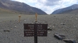
From the Tioga Pass entrance to Yosemite National Park... drive south 1.2 miles and park at the The Mono Pass Trailhead (9700').
|
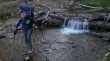
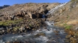
Denali Girl crossing the Dana Fork of the Tuolumne River.
|
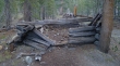
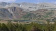
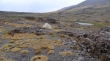
We found remnants of several cabins used by miners looking for silver.
|
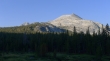
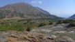
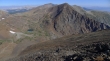
Mammoth Peak is located at the north end of Kuna Crest.
|
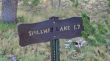
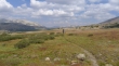
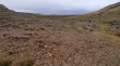
After hiking 2.3 miles we reached the junction with the trail to Spillway Lake... which we ignored.
|
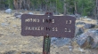
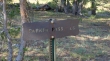
Immediately past the Spillway Lake trail junction, you will see the sign saying that Parker Pass is 3.5 miles away... this is incorrect... it is only 2.9 miles to the pass.
|
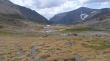
Kuna Crest from the trail to Parker Pass.
|
A quarter mile before reaching Mono Pass we turned right and headed for Parker Pass.
|
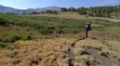
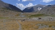
Denali Girl on the trail to Parker Pass... we will climb some of the peaks in the distance, but aren't sure which ones yet.
|
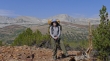
ragman on the trail to Parker Pass... Kuna Crest is behind.
|
Mt. Gibbs and Mono Pass as we head for Parker Pass.
|
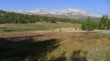
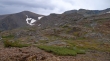
Spillway Lake and Kuna Crest as we head for Parker Pass.
|
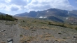
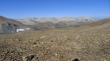
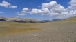
Approaching Parker Pass... it is huge.
|
Denali Girl in Parker Pass.
|
The official Parker Pass (11,100').
|
Some of the tarns on the east side of Parker Pass... we are looking for a campsite because clouds are forming fast.
|
We got the tent up before it started to rain... Parker Pass is behind.
|
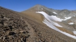
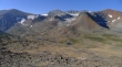
After a four hour rain storm, it quit raining and we were able to get out of the tent... Parker Peak on the left, Koip Peak Pass (center) and Koip Peak on the right.
|
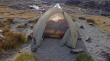
Our campsite at Parker Pass.
|
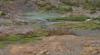
One of the pretty tarns on the east side of Parker Pass.
|
It is 7:15 pm and the weather is getting a little better... Parker Peak on the right and Mt. Lewis on the left.
|
We woke up on the second day to find sunshine and zero clouds.
|
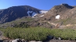
We are heading for Koip Peak Pass on a pretty nice trail... a beautiful stream not far from camp.
|
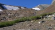
Parker Peak on the left... we are starting to get a better look at Koip Peak Pass (center).
|
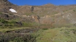
Another tarn along the way.
|
Koip Peak Pass and Koip Peak.
|
Denali Girl approaching the 32 nicely graded switchbacks leading up to Koip Peak Pass... Parker Pass at the top of the photo.
|
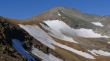
Mount Lewis from where we are starting up the switchbacks.
|
On the switchbacks now... every step higher gives a better look at Koip Peak Pass and Koip Peak.
|
Gaining elevation on the switchbacks.
|
Looking down on some of the many tarns on the east side of Parker Pass.
|
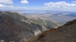
Looking east to Mono Lake (upper left)... Grant Lake (right) and Parker Lake (small).
|
Shouldn't be long now before the trail starts working its way over to Koip Peak Pass and Koip Peak.
|
Mount Lewis (foreground)... with Mt. Gibbs behind... Parker Pass on the left... and some of the many switchbacks.
|
Almost done with the switchbacks.
|
We can finally see the trail traversing over to Koip Peak Pass and Koip Peak.
|
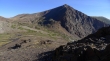
Mt. Gibbs (left) and Mt. Lewis (right) from Koip Peak Pass.
|
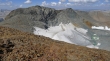
Looking down on some of the Alger Lakes from Koip Peak Pass... Blacktop Peak on the right.
|
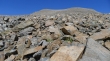
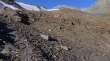
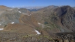
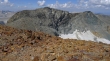
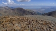
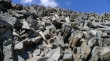
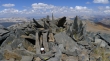
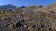
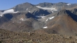
Koip Peak looks like a pile of rubble.
|
Ascending Koip Peak now... looking across Koip Peak Pass to Parker Peak and Mount Wood.
|
Almost to the Koip Peak summit.
|
Looking down on the Alger Lakes from the Koip Peak summit (12,979').
|
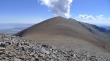
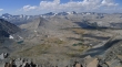
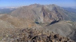
Looking SW from the Koip Peak summit... Mt. Lyell is in the center of the photo with the huge glacier on it... part of the Ritter Range on the left.
|
A closeup of Mount Lyell (center).
|
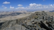
Kuna Peak from Koip Peak.
|
Mount Lewis (right)... with Mt. Gibbs and Mt. Dana in the center.
|
Mt. Lewis and Mono Lake from Koip Peak.
|
Time to head over to Kuna Peak.
|
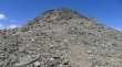
I will have to watch my footing on the way over to Kuna Peak.
|
Looking for the best route to the Kuna Peak summit.
|
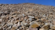
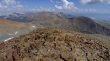
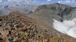
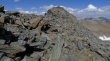
Looks like a pile of razor blades.
|
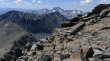
Ascending Kuna Peak now... looking across Blacktop Peak to Mt. Ritter and Banner Peak in the Ritter Range.
|
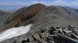
There is the Kuna Peak summit... it won't be long now.
|
Looking over to Koip Peak as I near the Kuna Peak summit.
|
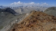
The Kuna Peak summit (13,002')... the third highest point in the park.
|
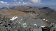
Donohue Peak (left-center foreground)... with Lost Lakes through the gap between Blacktop Peak and Donohue Peak.
|
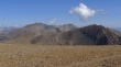
Looking west to a ton of peaks in Yosemite National Park.
|
Looking north.
|
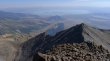
Mono Lake, Grant Lake and Parker Lake from the Kuna Peak summit.
|
We traced our steps back to our cozy camp.
|
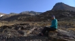
Denali Girl relaxes at our campsite.
|
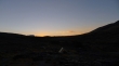
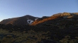
Sunset from our camp... I will do Mount Lewis tomorrow morning before heading back to the car.
|
Denali Girl will stay in camp while I head for Mount Lewis.
|
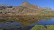
Tarn reflection.
|
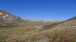
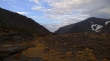
Looking over Parker Pass to Kuna Crest as I head for Mount Lewis.
|
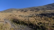
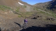
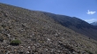
The terrain up to Lewis isn't very steep.
|
Looking down on our campsite as I ascend Mt. Lewis... Parker Peak, Koip Peak Pass, Koip Peak and Kuna Peak in the distance.
|
Ascending Mount Lewis.
|
Kuna Crest as I ascend Mt. Lewis.
|
A closeup of Koip Peak and Kuna Peak.
|
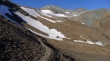
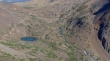
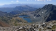
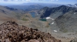
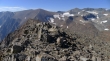
High enough now to see Helen Lake (left) and Spillway Lake below Kuna Crest.
|
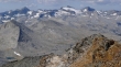
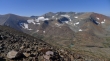
On the Mt. Lewis summit (12,296') now... Parker Peak (left), Blacktop Peak on the other side of Koip Peak Pass, Koip Peak and Kuna Peak.
|
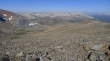
Looking down at a couple of tarns in Parker Pass... Parker Pass Lake below the snow... Helen Lake and Spillway Lake below Kuna Crest.
|
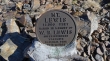
This says Mt. Lewis is 12,500 feet... but 12,296 feet is correct.
|
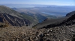
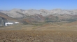
Looing at Lower Sardine Lake on the east side of Mono Pass... below Mt. Gibbs.
|
Walker Lake and Mono Lake from Mount Lewis.
|
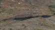
A closeup of our campsite in the center of the photo.
|
Heading down now.
|
Denali Girl coming up to Parker Pass.
|
Heading through Parker Pass.
|
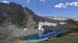
A brief stop off at Parker Pass Lake... which we missed on our way in to camp.
|
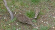
A couple of ptarmigans.
|
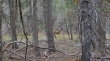
We saw a few deer on the trip... third day stats... 4 miles roundtrip to Mt. Lewis, gaining 1400 feet of elevation... and 5.5 miles from our campsite to the car, gaining 300 feet of elevation.
|
