Barrier Peak and Govenors Peak - 9.27.2012
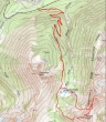
rodman's GPS route of our climb of Barrier Peak and Govenors Peak in Mount Rainier National Park... 10.25 miles roundtrip, gaining 3635 feet of elevation.
|
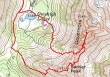
A closer look at rodman's GPS route... we left the Owyhigh Lakes Trail and headed east to Barrier Peak... then down and over to Govenors Peak... and found a nice exit gully on Govenors Ridge for our return to Owyhigh Lakes.
|
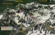
A google earth look at the terrain on the west side of Govenors Ridge... there wasn't any snow on our trip.
|
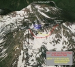
A google earth look at the terrain on the east side of Govenors Ridge... there wasn't any snow on our trip.
|
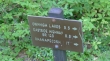
From the White River entrance to Mt. Rainier National Park... drive 2 miles to the trailhead parking area (3720') on the right side of the road. The trail starts on the left side of the road.
|
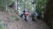
The 3.5 mile hike to Owyhigh Lakes is on an excellent trail... nicely graded switch backs where necessary.
|
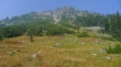
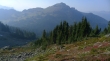
Nearing Owhigh Lakes (5183')... we could smell and taste the smoke from the fires in Eastern Washington... barely being able to see Govenors Ridge on the left.
|
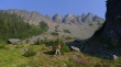
Looking up at Tamanos Mountain from Owyhigh Lakes.
|
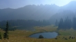
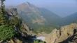
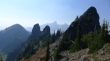
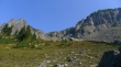
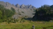
Owyhigh Lakes... with Govenors Ridge above... Barrier Peak on the far right... Govenors Peak is just left of center.
|
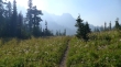
We have hiked about a half-mile beyond Owyhigh Lakes to where we got our first view of the Cowlitz Chimneys... this is where we will leave the trail and head east for Barrier Peak.
|
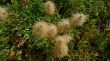
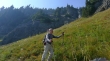
There were a bizillion western anemone in the open area around Owyhigh Lakes.
|
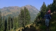
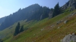
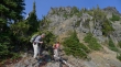
We are several hundred feet above the trail now... working our way up to the west ridge of Barrier Peak on a pretty good path... Tamanos Mountain is in the distance.
|
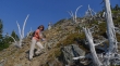
We have left the good path now and working our way up toward the huge rock outcropping on Barrier Peak's west ridge... with Rainier coming into view behind the Cowlitz Chimneys.
|
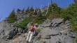
BarbE at the huge rock outcropping on the west ridge of Barrier Peak.
|
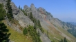
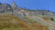
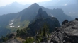
Barrier Peak on the far right... Govenors Peak is the rounded summit on the far left... we will return to Owyhigh Lakes via the gully in the center of the photo.
|
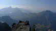
rodman on Barrier's west ridge... having just passed the huge rock outcropping... Rainier is on the left... Owyhigh Lakes below right.
|
Owyhigh Lakes and Tamanos Mountain from Barrier Peak's west ridge... the road to Sunrise is barely visible through the smoke.
|
BarbE and rodman on Barrier Peak's west ridge... Cowlitz Chimneys and Rainier behind.
|
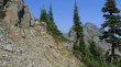
Clear sailing ahead to Barrier Peak.
|
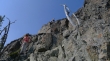
Nearing the Barrier Peak summit... the huge rock outcropping and our route along Barrier's west ridge is below.
|
Almost on the Barrier Peak summit... following an obvious path now.
|
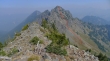
On the Barrier Peak summit (6521')... looking over at our route to Govenors Peak.
|
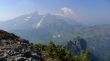
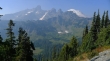
The Cowlitz Chimneys and Mount Rainier from Barrier Peak.
|
Tamanos Mountain and Owyhigh Lakes from the Barrier Peak summit.
|
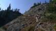
rodman coming down the east side of Barrier Peak... giving back some of the 500 feet of elevation that is necessary before we can traverse over to Govenors Peak in the distance.
|
Lordy, lordy... don't try this at home... Govenors Peak in the distance.
|
BarbE coming down the east side of Barrier Peak.
|
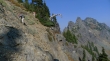
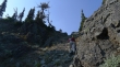
BarbE and rodman working their way down a gully on the east side of Barrier Peak.
|
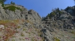
Still on the east side of Barrier Peak... looking over at our route up to Govenors Peak.
|
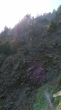
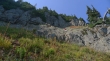
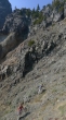
A bad photo... but it gives a good feel for the terrain on the east side of Barrier Peak.
|
rodman is able to exhale after getting down from the steep terrain on the east side of Barrier Peak.
|
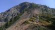
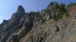
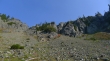
Looking back at Barrier Peak as we follow a faint path over toward a gully that will get us up to Govenors Peak.
|
At the base of the gully that will lead up to Govenors Peak... the summit is beyond the band of trees in the right center of the photo.
|
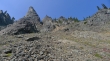
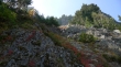
Heading up the gully now... lots of loose rock... we will eventually angle to the right.
|
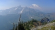
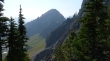
Looking over to Barrier Peak as we head up the gully toward Govenors Peak... Double Peak is in haze on the far left.
|
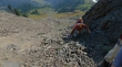
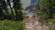
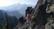
BarbE in the gully leading to Govenors Peak... trying to stay on solid rock.
|
BarbE and rodman in the gully leading up to Govenors Peak.
|
We are on fairly solid rock now... trying to reach the 'red' in the upper right of the photo.
|
Can you say 'veggie' belay... almost to easier terrain now.
|
Looking over to Barrier Peak.
|
High enough now to see the Cowlitz Chimneys in the distance... Barrier Peak on the far left.
|
On much easier terrain now... with the Govenors Peak summit on the left.
|
Heading for the Govenors Peak summit.
|
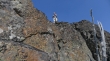
At the summit block now... with rodman leading the way.
|
BarbE working her way around to the west side of the summit block... the Cowlitz Chimneys and Mount Rainier in the distance.
|
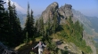
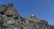
rodman is above... with summit register in hand.
|
BarbE near the summit.
|
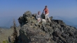
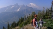
rodman and BarbE on the Govenors Peak summit (6614').
|
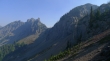
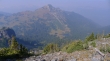
Looking south along Govenors Ridge to Barrier Peak... Double Peak is in the distance on the left.
|
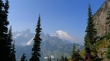
Cowlitz Chimneys (left) and Tamanos Mountain in the foreground... with Rainier behind.
|
BarbE used a Class 2 chimney to get back down from the summit block... a better choice than the route we used on the way up.
|
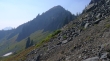
We are down from Govenors Peak and heading back toward Barrier Peak... looking for an exit gully on the north side of Barrier Peak that will get us back to Owyhigh Lakes.
|
rodman and BarbE heading for our exit gully.
|
rodman at the top of our exit gully... he can see Owyhigh Lakes below... Barrier Peak is out of frame on the left.
|
On the west side of Govenors Ridge now... looking back up at our exit gully in the center of the photo.
|
Losing elevation and heading for Owyhigh Lakes... our exit gully is on the left.
|
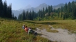
BarbE and rodman descending... with Tamanos Mountain behind.
|
Looking back up at our exit gully in the left center of the photo.
|
Govenors Peak summit on the far left... with our exit gully on the far right.
|
BarbE descending... with Govenors Ridge above... our exit gully is just out of frame on the right.
|
Looking back at Govenors Ridge and Barrier Peak (far right) as we head down toward Owyhigh Lakes.
|
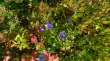
There were lots and lots of Gentian around Owyhigh Lakes.
|
A pano shot of Owyhigh Lakes... with Govenors Ridge and Barrier Peak on the left... and the Main Cowlitz Chimney on the far right.
|
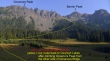
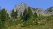
Govenors Peak and Barrier Peak from Owyhigh Lakes.
|
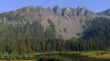
Govenors Ridge from Owyhigh Lakes... a 3.5 mile hike on excellent trail will get us back to the car... a long day in the wilderness.
|
