Mount Dickerman - 11.15.2012
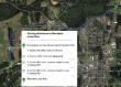
Approach Granite Falls from the west via Hwy 92... at the first roundabout, take Quarry Road... then stay with Quarry Road thru two more roundabouts until you reach the Mountain Loop Hwy.
|
At the intersection of Quarry Road and the Mountain Loop Hwy... turn left and follow the highway for 26.9 miles to the shared parking lot (1880') for Mt. Dickerman and Mt. Forgotten.
|
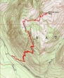
rodman's GPS track of our trip to the Mount Dickerman summit... 8 miles roundtrip, gaining 4011 feet of elevation.
|
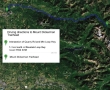
A google earth look at the terrain around Mount Dickerman.
|
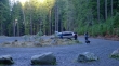
The large parking lot is shared by the Mount Dickerman trailhead and the Mount Forgotten trailhead.
|
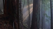
Sun beams tell us what to expect above... as we switchback up the first two miles of the trail in the dense forest.
|
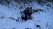
Izzy, rodman, Snowdog and BarbE on the Mount Dickerman trail... continuous snow at ~4000 feet.
|
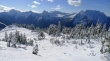
The terrain eases and opens up some at ~4400 feet.
|
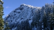
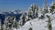
First good look at the west end of the Dickerman summit area.
|
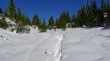
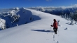
Snowshoes would have been helpful starting at ~4800 feet... as Snowdog leads the way up.
|
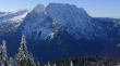
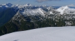
Looking SW across the valley at Big Four Mountain.
|
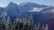
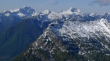
Looking SW across the valley to Sperry Peak (left) and Vesper Peak.
|
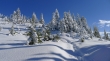
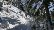
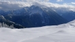
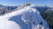
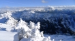
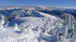
A winter wonderland.
|
Del Campo Peak (foreground) and Gothic Peak (behind and right) look like one mountain.
|
Continuing up Dickerman... with Three Fingers in the distance.
|
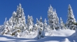
More winter wonderland.
|
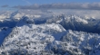
Looking SE to the Monte Cristo peaks.
|
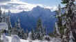
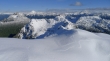
High enough now for an unobstructed view of Del Campo and Gothic on the far left... then Morning Star... with Sperry and Vesper in the center... and Big Four on the far right.
|
Looking across West Stillaguamish (left foreground) to Three Fingers and Whitehorse... Stillaguamish Peak in the right foreground... with Mount Baker in the distance on the far right.
|
A closeup of Three Fingers and Whitehorse.
|
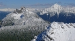
On the Dickerman summit (5723') now... Mount Forgotten and Mount Pugh on the left... on the right we are looking at Twin Peaks in the foreground... with Glacier Peak behind in the clouds... and Bedal Peak on the far right.
|
Looking north for this closeup of Mt. Forgotten (left) and Mount Pugh.
|
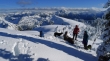
Izzy and the gang just below the Dickerman summit... seeking shelter from the wind... Glacier Peak, Bedal Peak and Sloan Peak in the distance.
|
BarbE and I decided to make the short trek over to the false summit... Sloan Peak (center) in the distance... with the Monte Cristo peaks on the far right.
|
Looking back at the true summit of Dickerman from the false summit... Three Fingers in the distance on the right.
|
BarbE on Dickerman's false summit... standing between Mount Forgotten and Mount Pugh.
|
Twin Peaks in the foreground... with Glacier Peak (left), Bedal Peak (center) and Sloan Peak (right) in the distance.
|
A closeup of Twin Peaks in the foreground... with Glacier Peak in the distance on the left... and Bedal Peak in the distance on the right.
|
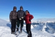
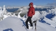
rodman took this photo of smiles on the Mount Dickerman summit.
|
Last look to the east before heading back to the car... Glacier Peak (left), Bedal Peak, Sloan Peak and the Monte Cristo Peaks.
|
