Broken Arrow Trail and Chicken Point - 4.22.2013
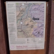
Directions to the Broken Arrow Trailhead.
|
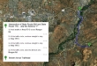
A google earth look at the terrain around Chicken Point... our hike was 3.5 miles roundtrip, gaining 400 feet of elevation.
|
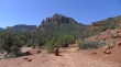
The trailhead is shared with the Margs Draw Trail.
|
One of the Twin Buttes as we hike along the Broken Arrow Trail.
|

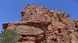
Awesome red rock formations.
|

Looking north to Wilson Mountain on the left.
|

Red rock.
|

A little later we will find a route up to those rabbit ears on the right.
|

Red rock.
|

At Chicken Point... looking out to Bell Rock in the distance.
|

Red Rock.
|

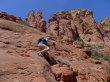
Denali Girl heading up to the rabbit ears on the left.
|
Getting steeper.
|

Next to the rabbit ears now... with a view of Cathedral Rock on the left... and the Church of the Holy Cross in the right foreground.
|

A closer look at the Church of the Holy Cross.
|
Nice rock.
|

More nice rock.
|

And still more nice rock.
|
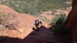
Denali Girl descending the Class 2 scramble.
|

ragman was there also.
|
