Goat Island Mountain - 7.9.2013
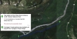
Directions from the fee station at the White River entrance to Mt. Rainier National Park to the Fryingpan Creek Parking area.
|
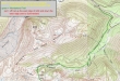
Our approximate route to the Goat Island Mountain summit... going up the east ridge and down the west ridge... ~11.5 miles roundtrip, gaining ~4200 feet of elevation.
|
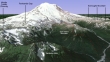
A google earth look at the terrain around Goat Island Mountain.
|
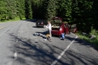
Gearing up at the Fryingpan Creek parking area (3800')... located just beyond the Fryingpan Creek Bridge.
|
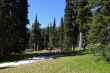
From the parking area we will use the short connector trail to get to the Wonderland Trail.
|
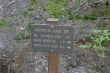
Turning right onto the Wonderland Trail... at the end of the day will close our loop hike here.
|
After hiking the Wonderland Trail for 10 minutes (~ a half mile) we found the east ridge of Goat Island Mtn and left the main trail.
|
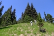
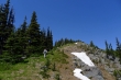
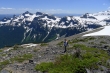
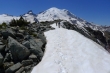
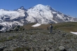
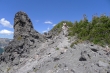
On the east ridge of Goat Island Mountain... much steeper than it looks in the photo.
|
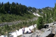
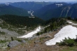
At ~5800 feet we left the east ridge and traveled SE into a basin... where we could see another east trending ridge that would take us to the summit.
|
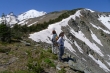
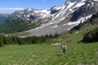
A short break before heading up to the ridge.
|

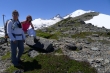
Working our way up to the ridge on a reasonable path.
|
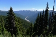
Looking down on the White River... with Sunrise Point on the far left of the photo.
|
On the ridge leading to the summit... easier terrain now.
|
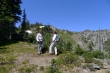
Snowdog and BarbE on the ridge leading to the summit.
|
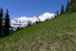
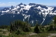
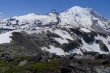
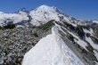
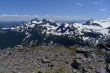
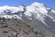
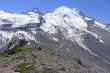
Our first good look at Little Tahoma and Mt. Rainier.
|
Continuing up the ridge.
|
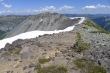
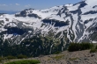
Looking down into the basin located at 5900 feet... and our general route where we switched ridges.
|
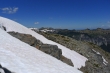
At this point we aren't sure which bump is the Goat Island Mountain summit.
|
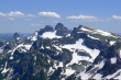
Looking over at the Cowlitz Chimneys and Banshee Peak... with Mt. Adams in the distance.
|
Looking over at the Sunrise area.
|
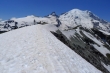
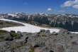
Now we can see the summit.
|
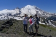
Group shot from the Goat Island Mountain summit (7288')... Snowdog has packed in a king size almond joy... whose lifespan lasted 10 seconds after this photo was taken.
|
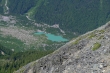
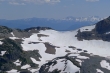
Beautiful lake down toward Glacier Basin... unnamed as far as I know.
|
Leaving the summit and starting the 2 mile ridge walk toward Mt. Rainier.
|
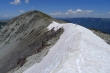
The ridge walk is going to be very very nice.
|
BarbE and Snowdog heading for the west end of Goat Island Mountain.
|
Looking back at the Goat Island Mountain summit.
|
Snowdog is very small in this photo.
|
Looking back at the Goat Island Mountain summit as we head for the west end of the mountain.
|
Continuing toward the west end of Goat Island Mountain.
|
Looking back at the Goat Island Mountain summit.
|
Looking across Panhandle Gap to Mt. Adams in the distance... Cowlitz Chimneys and Banshee Peak on the left.
|
The three Burroughs over by Sunrise.
|
Off of the gray and onto the brown as we get closer to the west end of Goat Island Mountain.
|
Serious glacier activity on Mount Rainier.
|
Looking down on Summerland... with Panhandle Gap on the far left.
|
A closeup of the Cowlitz Chimneys and Banshee Peak.
|
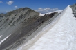
A closeup of Panhandle Gap... the cornice does not pose a problem... Goat Rocks in the distance.
|
We will cross over one more bump and then leave the ridge.
|
Still on the west ridge... but not for long.
|
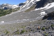
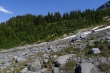
Descending from the west ridge of Goat Island Mountain... we will cross the lateral moraines and go over to Summerland.
|
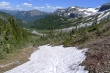
Using what little snow remains to our advantage.
|
We will need to find a safe crossing of Fryingpan Creek.
|
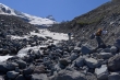
BarbE and Snowdog looking for a good place to cross Fryingpan Creek.
|
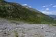
Safely across Fryingpan Creek now and heading down... Goat Island Mountain above on the left.
|
BarbE working her way over to Summerland where we will pick up the Wonderland Trail.
|
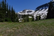
In Summerland now and looking up toward Panhandle Gap.
|
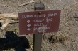
We will take a short break at the Summerland Camp.
|
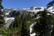
Looking up toward Panhandle Gap from the shelter in Summerland.
|
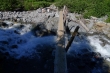
Another short break at the footbridge crossing of Fryingpan Creek... leaving a 3 mile hike on the Wonderland Trail to get back to the car.
|
