Volcanic Neck, Devils Head and Bean Peak - 7.15.2013
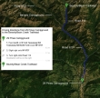
Directions from 29 Pines Campground to the Beverly Turnpike/Bean Creek Trailhead.
|
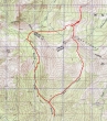
rodman's June, 2008 GPS route of our Volcanic Neck, Devils Head, Bean Peak hike/climb... the same route for this trip... 9.5 miles roundtrip, gaining 3668 feet of elevation.
|
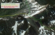
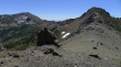
A google earth look at the terrain around Volcanic Neck and Bean Peak.
|
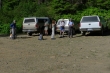
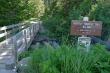
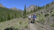
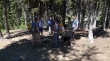
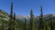
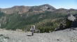
Gearing up at the Beverly Turnpike/Bean Creek Trailhead (3600').
|
We will use the Turnpike on the way in and come back via the Bean Creek trail.
|
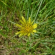
Pretty... but no idea what it is.
|
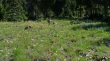
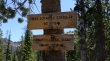
After hiking a half-mile we reached the junction of the Beverly Turnpike and Bean Creek Trails... we will continue on the Turnpike.
|
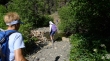
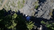
The crossing of Bean Creek was easy.
|
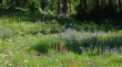
Beautiful meadows full of flowers as we continue up the Beverly Turnpike Trail... find Izzy.
|
The trail switch backs through the flower fields.
|
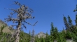
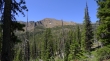
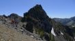
First look at Bills Peak at the head of the valley.
|
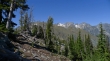
Continuing up on the Beverly Turnpike Trail... Teanaway Peak is in view on the left.
|
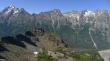
We have reached a junction (5200') where we will leave the Beverly Turnpike by turning right to follow the County Line Trail a half-mile up to Fourth Creek Pass.
|
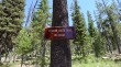
This sign is also at the junction of the Turnpike and County Line Trails... although newer maps do not recognize the trail number... however, it still goes up to Fourth Creek Pass... and that is where we are going.
|
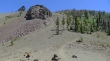
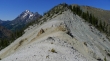
Looking across the valley at Iron Peak as we head for Fourth Creek Pass.
|
We are at Fourth Creek Pass... we will continue on the County Line Trail... in the direction of the junction with the Hardscrabble Creek Trail.
|
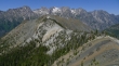
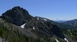
Some of the Stuart Range... as we hike along the County Line Trail on the NW side of Bean Peak.
|
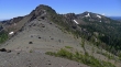
On the County Line Trail... and heading up to the ridge between Volcanic Neck and Bean Peak.
|
Snowdog arriving at the ridge... Bean Peak (center) with Marys Peak on the right... Mt. Rainier in the distance.
|
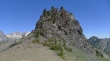
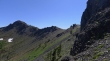
The south side of Volcanic Neck from the saddle between the Neck and Bean Peak.
|
|
A pano shot from the Neck/Bean saddle... Fortune and Ingalls Peak on the left... Mt. Stuart (center), Sherpa, Argonaut, Colchuck and Dragontail.
|
larman is coming down from Bean Peak to join us for Volcanic Neck and Devils Head... Earl Peak on the left.
|
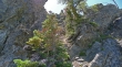
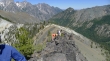
Looking up from the SE side of Volcanic Neck... as we follow a boot path that will lead us around to the north side of the Neck.
|
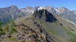
The gang is following me along the SE side of Volcanic Neck.
|
Continuing on the path on the SE side of Volcanic Neck... working our way around to the north side of the Neck... Navaho Peak in the distance on the right.
|
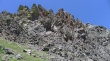
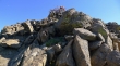
A little rock work just before reaching the north side of Volcanic Neck.
|
On the north side of Volcanic Neck now... Earl Peak in the distance.
|
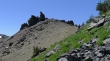
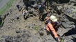
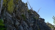
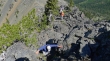
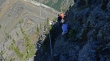
The adventure starts at this dirt and gravel gully on the north side of the Neck... steeper than it looks in the photo.
|
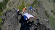
I'm at the top of the dirt and gravel gully watching the troops as they come up... a couple of veggie belays help here.
|
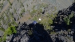
At the top of the dirt and gravel gully we followed a faint path around to the right... where we will continue up now.
|
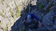
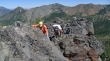
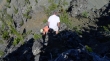
BarbE, robman and tomman coming up.
|
BarbE and larman... we are following a faint path.
|
Still ascending Volcanic Neck.
|
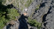
The hardest part has been completed.
|
Ascending now on easier terrain.
|
Almost there now... the eastern end of the Stuart Range is upper left.
|
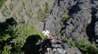
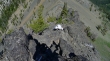
BarbE is two steps away from the summit... Navaho Peak and Three Brothers in the distance.
|
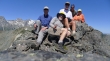
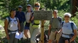
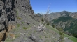
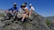
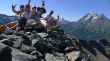
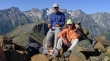
Group shot on the summit (6600')... tomman, ragman, larman, robman and BarbE... wow, that is a lot of mans... with Colchuck and Dragontail Peaks in the distance.
|
robman is heading back down to keep an eye on Izzy while Snowdog comes up to join the summit party.
|
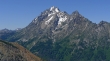
Mount Stuart and Sherpa Peak from the Volcanic Neck summit.
|
Bean Peak, Marys Peak and Mount Rainier from the Volcanic Neck summit.
|
Navaho Peak (left) and Earl Peak from the Volcanic Neck summit.
|
When we get back down the Neck, we will follow this ridge over to Devils Head... in the distance are Argonaut (left), Colchuck, Dragontail, Little Annapurna and McClellan.
|
Looking back at the Volcanic Neck summit as I have walked over to see if Snowdog is coming up... Bills Peak on the right.
|
Sure enough... Snowdog is on her way up.
|
Summit group shot number two... BarbE (lower right in photo) is already thinking about how to get back down.
|
Leaving the Volcanic Neck summit.
|
Going down... rock huggers.
|
Still going down.
|
Descending.
|
Snowdog is almost back down to the top of the dirt and gravel gully.
|
BarbE and larman are almost back to the top of the dirt and gravel gully.
|
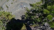
Looking down on our group from the top of the dirt and gravel gully.
|
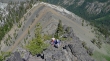
Leaving the Volcanic Neck and on our way out to Devils Head.
|
Snowdog leads the way to Devils Head (left foreground)... with part of the Stuart Range in the distance.
|
Snowdog and Izzy on the ridge leading to Devils Head... looks like a moonscape... Mt. Stuart and Sherpa Peak in the distance on the left.
|
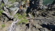
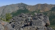
Looking back at the sheer NW side of Volcanic Neck.
|
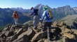
robman and larman work around one of several rock outcroppings on the ridge leading to Devils Head... Earl Peak in the distance.
|
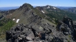
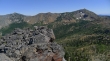
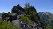
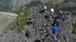
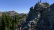
A bunch of little devils on the Devils Head summit (6666')... Stuart and Sherpa on the right.
|
Stuart, Sherpa, Argonaut, Colchuck and Dragontail from Devils Head.
|
Heading back from Devils Head toward Volcanic Neck... Earl Peak on the left... Marys Peak on the right.
|
robman coming back along the ridge from Devils Head... Stuart and Sherpa on the left.
|
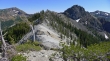
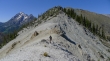
Back on the SE side of Volcanic Neck now... and we can see the ridge route that will take us up to Bean Peak.
|
Nearing the Bean Peak summit... and looking back at Volcanic Neck... with Argonaut, Colchuck, Dragontail and Little Annapurna in the distance.
|
BarbE is ready to step on the summit of Bean Peak.
|
Snack time for tomman and BarbE on the Bean Peak summit (6743').
|
Leaving the Bean Peak summit.
|
Working our way down the summit block of Bean Peak.
|
Almost off of the summit block of Bean Peak.
|
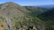
Earl Peak on the left... as we head for the green of Bean Creek Basin below... which will leave a nice 3 mile trail-hike back to our cars.
|
