Middle Chiwaukum, North Chiwaukum and Point 6935 - 8.14.2013
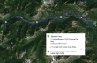
Directions from Stevens Pass to the fenced parking lot for Scottish Lakes High Camp.
|
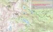
The approximate route of our loop hike and scramble... starting and ending at Scottish Lakes High Camp... 11 to 12 miles roundtrip, gaining 3600 feet of elevation.
|
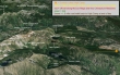
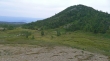
A google earth look at the terrain around McCue Ridge.
|
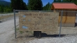
The fenced parking area for Scottish Lakes High Camp... located just across Hwy 2 from the Rest Area between Stevens Pass and Coles Corner. This is where the Scottish Lakes High Camp personnel will pick you up.
|
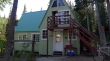
The lodge at Scottish Lakes High Camp is located at ~5000 feet.
|
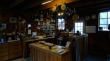
Inside the lodge at Scottish Lakes High Camp.
|
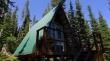
Denali Girl relaxes on the deck of the Gentian Cabin... one of nine cabins that are available.
|
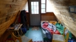
Inside the Gentian Cabin... there is a wood burning stove and a propane powered stove behind me.
|
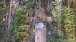
Our hiking adventure started on the Mac's Express ski trail... located behind the lodge.
|
After hiking on Mac's Express for a short distance, we used the Cliffhanger Trail to get up to McCue Ridge (5600').
|
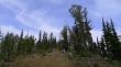
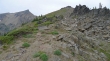
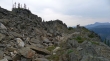
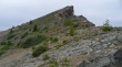
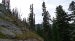
Hiking along McCue Ridge on a faint trail.
|
Crossing into the Alpine Lakes Wilderness on McCue Ridge.
|
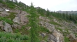
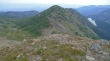
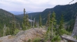
Heading west on McCue Ridge.
|
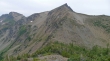
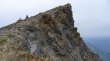
On McCue Ridge... looking at Point 6935 (aka Tamarack Peak to the locals).
|
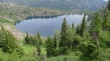
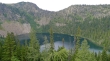
Denali Girl on McCue Ridge... looking down on Chiwaukum Lake.
|
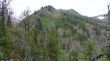
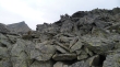
The ridge narrows and is very steep above Lake Donald.
|
Past Lake Donald now... and heading up toward Point 6935 on McCue Ridge.
|
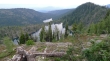
Still working our way toward Point 6935... and looking back at Lake Donald in the foreground and Lake Julius.
|
On the north side of McCue Ridge and heading for Point 6935 above.
|
Nearing Point 6935... with Middle Chiwaukum (aka McWaukum to the locals) in the distance on the left.
|
Denali Girl on the south side of McCue Ridge.
|
Nearing the summit of Point 6935... with Middle Chiwaukum on the far left.
|
Denali Girl nearing the summit of Point 6935... Lake Julius and Lake Donald on the left.
|
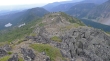
On Point 6935 now... with Middle Chiwaukum on the left... and North Chiwaukum above the snow field on the right.
|
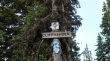
Fred Beavon placed a film canister register in 2006... and named Point 6935 as McCue Peak... a good choice since it is the high point on McCue Ridge.
|
We have left Point 6935 and are continuing west along McCue Ridge... looks like we will have to give up a little elevation before heading up to Middle Chiwaukum.
|
Looking back at Denali Girl on Point 6935 as I head for the summit of Middle Chiwaukum... Chiwaukum Meadows on the left... with Chiwaukum Lake on the right.
|
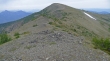
Getting closer to the summit of Middle Chiwaukum.
|
One final push remains to reach the summit... I think I will use the route on the left side of the photo.
|
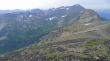
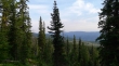
Looking south from the Middle Chiwaukum summit (7423')... the ridge on the right leads out to Big Chiwaukum and Snowgrass Mountain... Larch Lake is in the center of the photo with Cup Lake barely visible above it to the right... the Stuart Range is barely visible in the distant haze on the left.
|
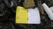
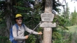
Fay Pullen placed the register in 2005... There were quite a few familiar nwhiker names in it.
|
I have left the Middle Chiwaukum summit... giving back 400 feet of elevation and heading for North Chiwaukum (aka Mt. Baldy to the locals)... a stroll in the park. I can barely see Glacier Peak thru the haze on the far left.
|
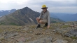
Self portriat from the summit of North Chiwaukum... with Middle Chiwaukum behind me... Snowgrass Mountain and Big Chiwaukum in the distance on the left.
|
Leaving North Chiwaukum and heading down to meet Denali Girl in Chiwaukum Meadows... Point 6935 on the right.
|
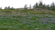
Denali Girl and lots of lupine in Chiwaukum Meadows.
|
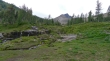
We are descending via Chiwaukum Meadows... and looking back at Middle Chiwaukum.
|
Descending through Chiwaukum Meadows.
|
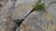
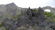
Lots of rock patterns.
|
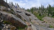
Still descending... nearing Lake Donald... we will find a cairned route that will lead us down to Loch Eileen.
|
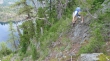
Denali Girl descending on sticky rock.
|
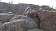
I guess this makes it a Class 2 hike.
|
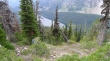
Above Loch Eileen... still following a cairned route that will take us down to the lake.
|
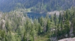
Lake Julius is down valley... we will pass by it on the way back to High Camp.
|
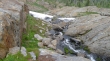
Very steep terrain between Lake Donald and Loch Eileen... the cairned route is really appreciated.
|
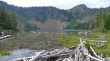
Finally down to Loch Eileen where we will find some real trail... leaving a 3 or 4 mile hike back to High Camp.
|
