Sandia Crest (La Luz Trail) - 4.11.2014
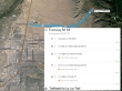
From the junction of I-25 and NM-556... the La Luz Trailhead is 6.5 miles east of Albuquerque using NM-556 and Forest Service Road 333.
|
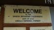
The La Luz Trail is in the Sandia Mountain Wilderness of the Cibola National Forest.
|
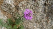
No idea on this one... but it is one of my favorite colors.
|
This trail has been adopted by the Albuquerque Road Runners Club... for me it is hard to imagine running uphill to the Sandia Crest... a run of 7.5 miles that gains 3775 feet of elevation... then 7.5 miles back down to the trailhead.
|
A person could head over to a tram that goes up near the summit... but I will continue for the crest on trail.
|
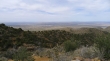
High enough now to look back on Albuquerque.
|
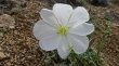
Lots of Evening Primrose on this hike.
|
Looking back on Albuquerque... and down on part of the La Luz Trail.
|
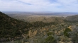
Steadily gaining elevation.
|
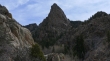
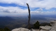
The Thumb.
|
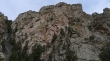
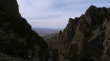
Canyon walls.
|
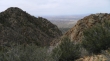
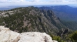
Looking down on the La Luz Trail below as I gain elevation... Albuquerque in the distance.
|
Still gaining elevation.
|
After hiking 7 miles I have reached a decision point... left is a half-mile to the Sandia Crest... right is a mile over to the top of the tram. I'm heading for the crest.
|
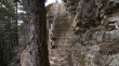
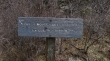
I didn't see this coming... but I'm glad it was there.
|
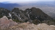
Almost to the crest... looking down on one of the many switchbacks on the La Luz Trail.
|
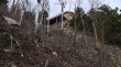
At last... the Crest House.
|
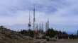
Lots of communication towers on Sandia Crest (10, 678').
|
Albuquerque from Sandia Crest.
|
The tram from near Sandia Crest... hey I still have a 7.5 mile hike back down to the car... ugh!... too bad the tram wasn't operating.
|
