Bean Peak, Mary Peak and Judy Peak - 5.31.2014
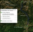
Directions from the entrance to 29 Pines Campground to the Bean/Beverly Trailhead.
|
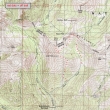
Our approximate route on this trip... off trail more than half of the time... ~8 miles roundtrip, gaining ~3800 feet of elevation.
|
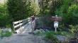
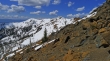
Sahale at the Beverly Turnpike Trailhead (~3600').
|
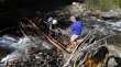
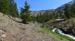
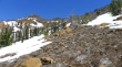
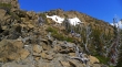
There was a pretty good makeshift bridge for the crossing of Bean Creek.
|
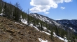
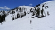
We are at the junction with the trail that goes up toward Earl Peak... and still haven't hiked on any snow.
|
Luna and Sahale in Bean Creek Basin... Bean Peak above.
|
madman straddles a crevasse in Bean Creek Basin... okay, that's a stretch.
|
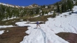
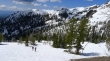
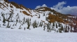
Break time in Bean Creek Basin.
|
Looking over at Earl Peak as we head up toward the ridge that connects Earl Peak and Bean Peak.
|
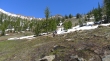
Still heading for the ridge.
|
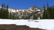
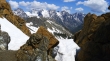
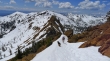
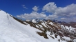
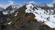
madman and Sahale above Bean Creek Basin... Judy Peak (center) on the ridge across the basin... with Mary Peak on the far right.
|
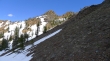
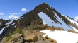
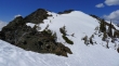
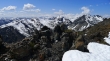
Steeper terrain now... looking at Bean Peak as we work our way up to the ridge.
|
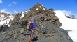
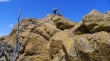
madman on the ridge between Earl and Bean... what is he looking at?
|
madman was looking at the Stuart Range from the Earl/Bean ridge.
|
Looking at the ridge that runs from Bean Peak over to Earl Peak... Navaho Peak on the far left.
|
Heading for the Bean Peak summit.
|
Heading for the Bean Peak summit and looking over at Judy Peak (left) and Mary Peak on the right.
|
Sahale and madman soaking up the view below Bean Peak... Luna is there also, but she blends into the color of the rock.
|
There's Luna.
|
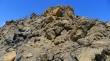
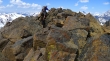
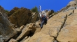
Continuing up.
|

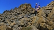
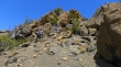
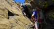
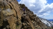
More difficult terrain now.
|
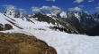
A nice look over at the Stuart Range.
|
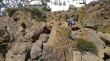
Sahale on the rock.
|
Here come madman, Sahale and Luna.
|
Sahale continuing up.
|
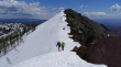
Sahale can see the summit, but there is still work to do.
|
Almost on the summit... Bean Creek Basin below.
|
madman and Luna are ready to step onto the summit.
|
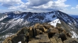
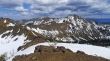
On the Bean Peak summit (6743')... Mt. Stuart and Sherpa Peak on the right.
|
A pano shot of the Stuart Range from the Bean Peak summit... Mt. Stuart, Sherpa Peak, Argonaut Peak, Colchuck Peak, Dragontail Peak and Little Annapurna... with Volcanic Neck in the right foreground.
|
Navaho Peak (far left) and Earl Peak from Bean Peak.
|
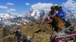
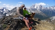
Group shot from the Bean Peak summit... madman, ragman and Sahale... with Luna in the front row.
|
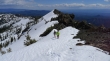
Descending the SW side of Bean Peak.
|
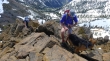
Luna keeps a watchful eye on Sahale as she descends.
|
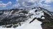
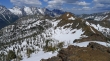
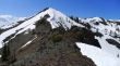
Finding our way down off of Bean Peak... looking over at Mary Peak and Judy Peak.
|
On easier terrain now... looking back at Bean Peak.
|
Looking back at Bean Peak as we head over to Judy and Mary.
|
madman, Luna and Sahale lead the way toward Judy Peak.
|
Nearing the saddle between Judy Peak and Mary Peak... looking over at Bean Peak... and the Stuart Range beyond.
|
We are heading for Mary Peak... looking back on Judy Peak.
|
Sahale, Luna and madman on their way to the Mary Peak summit.
|
The Stuart Range and Bean Peak from the Mary Peak summit.
|
Bean Peak on the far left and Earl Peak on the right.
|
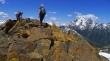
madman, Sahale and Luna on the Mary Peak summit (6680+).
|
We have left the Mary Peak summit and will go over to the Judy Peak summit.
|

Following the ridge over to Judy Peak.
|
On the Judy Peak summit (6560+)... the foreground peaks are Iron (left), Teanaway (center) and Bill (right).
|
Sahale and madman coming over to join me on Judy Peak... Mt. Stuart and Sherpa Peak tower over Mary Peak in the center of the photo... Bill Peak on the left... with Argonaut and Colchuck on the right.
|
Looking back at Judy Peak as we continue SE along the ridge... Mary Peak in the distance on the right.
|
Luna says it is time to get off of the ridge and head down to find the Bean Creek Trail... where we will close the loop portion of our hike... leaving a mile of easy walking back to our car.
|
