Tamanos Mountain - 10.19.2014
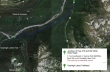
Directions from the junction of Hwy 410 and the White River Road to the trailhead for Owyhigh Lakes... our starting point for Tamanos Mountain.
|
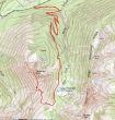
rodman's GPS track from October, 2011... the same route we used for this trip... 9.75 miles roundtrip, gaining 3490 feet of elevation.
|
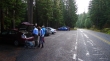
We drove ~2 miles from the fee station at the White River entrance of Mt. Rainier National Park to the Owyhigh Lakes Trailhead (~3720')... room for a dozen cars.
|
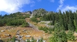
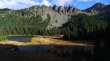
After hiking 3.5 miles we came out of the trees at Owyhigh Lakes (~5200') and are looking up at the east side of Tamanos Mountain.
|
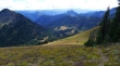
We will hike on the trail for a quarter mile past Owyhigh Lakes... then leave the main trail in a large meadow and follow a path that leads up to the ridge south of the Tamanos Mountain summit... Govenors Ridge is above the lakes... with Barrier Mountain on the far right.
|
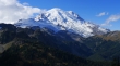
Awesome views of Mt. Rainier from the ridge (~6300') south of the Tamanos Mountain summit.
|
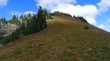
Looking up toward the Tamanos summit area from the ridge south of the summit... a good path willl take us up to the false summit.
|
Looking across the valley at Govenors Ridge and Barrier Peak as we continue toward the false summit of Tamanos Mountain.
|
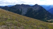
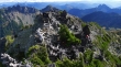
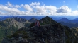
Continuing up the south ridge of Tamanos Mountain... looking south to Barrier Peak on the extreme far left... with Double Peak in the center of the photo.
|

The Cowlitz Chimneys on the left... with Banshee Peak above the Sarvant Glacier on the right.
|
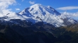
Mount Rainier from the false summit (~6720') of Tamanos Mountain.
|
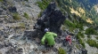
I am looking back at the false summit as I watch BarbE and tomman (lower right in the photo) working their way over to where I am.
|
tomman and BarbE on the ridge leading from the false summit of Tamanos to the true summit.
|
Still on the ridge leading from the false summit to the true summit... Govenors Ridge on the left... and Double Peak on the right.
|
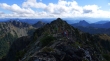
Almost on the true summit of Tamanos Mountain... with Govenors Ridge and Barrier Peak in the sunshine on the left... and Double Peak on the right.
|
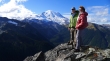
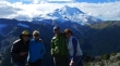
tomman and BarbE on the true summit (6790') of Tamanos Mountain... with Mt. Rainier in the distance.
|
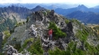
Heading back to the false summit of Tamanos Mountain... there is some solid Class 2 scrambling to do between the false summit and true summit.
|
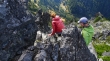
BarbE takes a shot of tomman on the scramble between the false summit and true summit of Tamanos Mountain.
|
Group shot from the false summit of Tamanos Mountain... ragman, Denali Girl, tomman and BarbE.
|
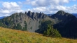
Hiking back down the south ridge of Tamanos Mountain... looking across the valley at Govenors Ridge and Barrier Peak (right)... still have a 4.5 mile hike to get back to the car.
|
