Teanaway Ridge and Iron Bear Mountain - 11.5.2014
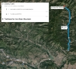
Directions from the Liberty Cafe on Hwy 97 to the trailhead for Iron Bear Mountain.
|
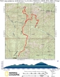
rodman's GPS track for our trip to Teanaway Ridge and Iron Bear Mountain... 11 miles roundtrip, gaining 3084 feet of elevation.
|
The trailhead is at the end of FS-9714 (~3640').
|
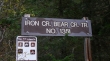
After hiking ~2 miles we reached a pass (`4500') that separates the Iron Creek drainage from the Bear Creek drainage. We will go left (south) and hike ~2 miles to Point 4943 on Teanaway Ridge.
|
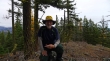
For the most part, Point 4943 is a treed summit.
|
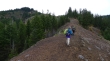
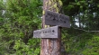
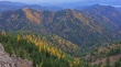
We have traced our steps back along Teanaway Ridge to the divide that separates Iron and Bear Creeks... and are now heading for Iron Bear Mountain on the left.
|
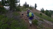
After hiking a mile or so from the Iron/Bear divide we are nearing the Iron Bear summit.
|
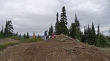
rodman and snowdog on the Iron Bear summit (5489').
|
Bearjack Ridge from the summit of Iron Bear Mountain... Bearjack-East is one of the two bumps in the foreground.
|
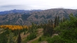
A nice stand of Larch Trees... with Miller Peak in the right foreground... Earl Peak in the distance on the left... with Navaho Peak covered with clouds in the center.
|
