Granite Mountain - 11.19.2014
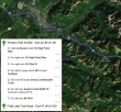
Directions from the Preston P&R to the Pratt Lake Trailhead... the starting point for our hike to Granite Mountain.
|
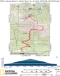
rodman's GPS track for our trip to Granite Mountain... 8 miles roundtrip, gaining 3834 feet of elevation.
|
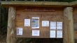
The Pratt Lake Trailhead (~1900') is located on the north side of I-90... near Exit 47.
|
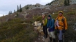
Yes... it was very chilly today.
|

After hiking ~1 mile we turned right onto the Granite Mountain Trail.
|
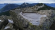
After hiking ~3 miles we got our first view of the Granite Mountain Lookout.
|
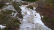
Above 4600 feet the trail was very icy in places.
|
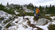
Below the lookout now... in the basin on the east side of Granite Mountain.
|
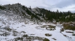
Getting closer now... perhaps a half-mile of hiking to go.
|
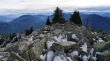
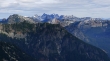
Looking south from the summit (5629') of Granite Mountain.
|
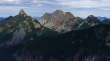
Kaleetan Peak (left), Chair Peak and Bryant Peak from the summit of Granite Mountain.
|
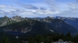
Looking west from the Granite Mountain summit... Pratt Mountain is in front of Mount Defiance in the center of the photo... Bandera Mountain is in the left foreground... with Tusk O'Granite in the right foreground.
|
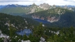
Looking down on Crystal Lake (bottom of photo) and Tuscohatchie Lake... Preacher Mountain on the far left... Kaleetan, Chair and Bryant in the center... with The Tooth and Big Snow Mountain on the right.
|
Looking across Low Mountain to the foreground peaks of Snoqualmie Mountain on the left, Mt. Thomson (pyramid shape) and Red Mountain (it is red), Guye Peak and Kendall Peak on the right... with distant peaks that include Overcoat, Chimney Rock, Lemah, Chikamin and Four Brothers.
|
Looking into the heart of the Alpine Lakes Wilderness from the summit of Granite Mountain.
|
