Arrowhead Mountain - 1.26.2009
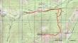
rodman's GPS route for Arrowhead Mtn... park at a turnout on the north side of US 2 (2750')... ~1.5 miles east of the Stevens Pass Nordic Center.
|
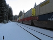
Cross US 2 and walk east on the railroad track for ~1 mile... hint, watch and listen for trains.
|
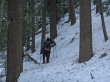
rodman and madman have left the railraod track and heading due south for the east ridge of Arrowhead Mtn.
|

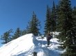
We've reached the east ridge (4800') of Arrowhead Mtn and decided to leave the snowshoes behind.
|
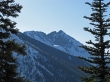
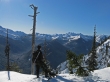
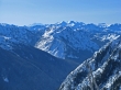
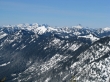
Nice views of the Chiwaukum Mountains as we hike along Arrowhead's east ridge.
|
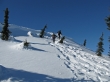
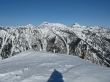
rodman working his way along Arrowhead's east ridge.
|
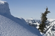
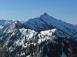
madman checks out Bulls Tooth from Arrowhead's east ridge.
|
Just before reaching Arrowhead's summit madman got this shot of Sloan Peak.
|
rodman and madman getting ready to step onto the Arrowhead Mtn summit (6030').
|

At the Arrowhead summit madman captures the snotcicles on ragman.
|
Jim Hill Mtn from Arrowhead... Rainier, Daniel, and Hinman are on the left in the distance.
|
A closeup of Rainier, Daniel, and Hinman from Arrowhead Mtn.
|
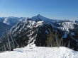
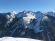
Glacier Peak, Rock Mtn and Mt. Howard from the Arrowhead summit.
|
A closeup of Jim Hill Mtn from Arrowhead Mtn.
|
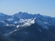
The Monte Cristo Peaks and Sloan Peak from Arrowhead Mtn.
|
A closeup of Doughgob Mtn, Bulls Tooth and Lemool Mtn from Arrowhead Mtn.
|
Some of the Chiwaukum Mountains from Arrowhead Mtn.
|
Panorama shot of the Chiwaukum Mountains from Arrowhead Mtn.
|
Panorama shot from Arrowhead Mtn showing the Chiwaukum Mtns on the left to Jim Hill Mtn on the right.
|
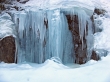
On our return to the car we check out some of the ice falls along the railroad track... 7.25 miles roundtrip, gaining 3562 feet of elevation.
|
