MTTA High Hut - 4.7.2009
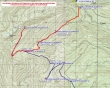
The Mount Tahoma Trail Association's High Hut is 9 miles roundtrip, gaining 2400 feet of elevation... from Whittaker's Bunkhouse in Ashford, drive 2.4 miles east on State Route 706... turn right on Kernahan Road and follow the signs for the MTTA sno-park.
|
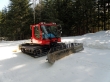
Parking at the lower sno-park (2360')... I skied for ~1.5 miles and found the grooming machine at the second sno-park.
|
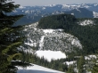
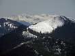
Nearing the High Hut I looked down on Anderson Lake.
|
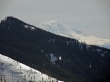
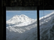
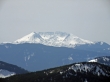
A zoom shot of Mt. Adams.
|
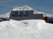
Solar panels on the High Hut (4760') roof... with a big mountain on the other side of the hut.
|
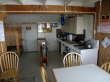
Inside the High Hut... calling it a hut is kind of a stretch.
|
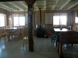
Another inside shot of the High Hut... visit their website at www.skimtta.com for info on reserving your overnight stay.
|
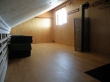
The High Hut sleeping loft... which has a door leading outside to the upper deck.
|
A pretty nice view from the High Hut dining area.
|
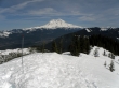
Mt. Rainier from the High Hut upper deck.
|
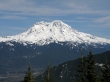
A zoom shot of Mt. Rainier from the High Hut.
|
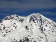
A zoom zoom zoom shot of Mt. Rainier from the High Hut.
|
A zoom shot of Mt. St. Helens from the High Hut.
|
A zoom shot of Goat Rocks from the High Hut.
|
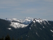
A zoom shot of the Tatoosh Range from the High Hut.
|
