Foss Peak - 5.17.2009
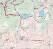
The Stevens Canyon Road was closed so we parked at Narada Falls in Mt. Rainier Nat. Park... this is a map and not a GPS route.
|
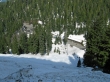
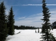
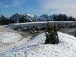
From the Narada Falls parking area (4600') we had to climb this steep embankment up to the Stevens Canyon Road.
|
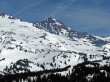
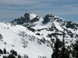
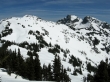
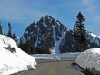
Chutla Peak and Eagle Peak in the Tatoosh Range.
|
Denali Girl and rdyhiker... with The Castle and Pinnacle Peak in the distance.
|
We arrived at Reflection Lakes after walking the road for ~1 mile.
|
Denali Girl and rdyhiker... after leaving the road at Reflection Lakes.
|
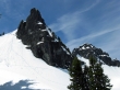
The Castle and Pinnacle Peak... we are heading for the ridge on the left side of The Castle.
|
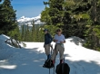
ragman and Denali Girl take a break... with Pyramid Peak in the distance.
|
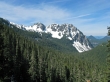
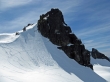
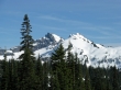
A closeup of Little Tahoma.
|
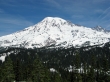
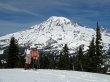
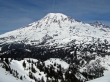
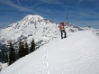
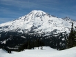
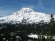
Our first clean look at Mt. Rainier.
|
rdyhiker and Denali Girl below The Castle.
|
The Castle... we are heading for the ridge to the left of it.
|
The east side of Pinnacle Peak as we head for The Castle.
|
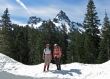
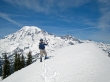
Denali Girl and rdyhiker in front of Mt. Rainier.
|
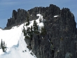
The Castle takes on a different look from the east... Pinnacle Peak on the right.
|
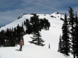
Watching climbers from the ridge on the east side of The Castle.
|
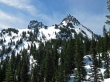
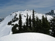
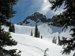
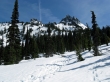
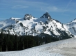
From the ridge we can see Unicorn Peak and Boundary Peak.
|
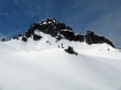
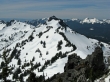
Our target is Foss Peak in the center... with Unicorn Peak on the right.
|
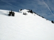
ragman starts giving back 200 feet of elevation on the way over to Foss Peak.
|
Mt. Rainier from the ridge between The Castle and Foss Peak.
|
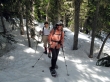
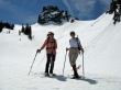
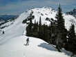
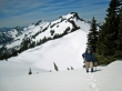
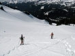
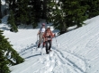
rdyhiker is almost ready to start uphill for the summit.
|
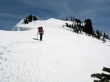
ragman on the way to the Foss Peak summit... with The Castle behind.
|
The Foss Peak summit is close.
|
rdyhiker nears the Foss Peak summit.
|
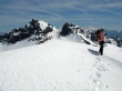
rdyhiker on the Foss Peak summit (6524').
|
ragman made the summit also.
|
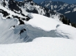
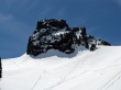
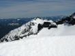
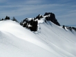
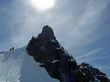
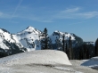
Cornice near the Foss Peak summit.
|
From the Foss summit... The Castle and Pinnacle Peak look like one peak... Plummer Peak on the left... with Iron Mtn and Copper Mtn on the right.
|
Stevens Peak at the east end of The Tatoosh Range.
|
rdyhiker on the Foss summit... with Unicorn Peak, Boundary Peak and Mt. Adams in the distance.
|
rdyhiker heading back towards The Castle from the Foss Peak summit.
|
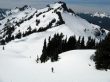
rdyhiker descending from Foss Peak... almost back to the low point on the ridge.
|
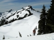
The corniced ridge we will travel back to The Castle.
|
Looking back to Foss Peak, Unicorn Peak and Boundary Peak.
|
We've made it back to the east side of The Castle.
|
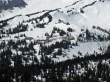
A closeup of the Paradise lodge and visitors center.
|
Sun dog over The Castle.
|
Denali Girl and rdyhiker heading down from the ridge east of The Castle.
|
Mt. Rainier as we head back towards Reflection Lakes.
|
Looking back on Pinnacle Peak as we head down.
|
Now we can see Reflection Lakes.
|
Denali Girl and rdyhiker are back in the trees and heading down.
|
Looking back on The Castle and Pinnacle Peak as we near Reflection Lakes.
|
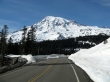
Mt. Rainier from the Stevens Canyon Road as we near Narada Falls.
|
Looking back on Lane Peak as we near Narada Falls.
|
We drove over to Paradise and got this look at Unicorn Peak and Foss Peak.
|
The Castle and Pinnacle Peak from Paradise.
|
Plummer Peak and Denman Peak from Paradise.
|
Lane Peak, Wahpenayo Peak, Chutla Peak and Eagle Peak from Paradise.
|
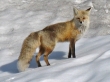
The posing fox near Paradise.
|
