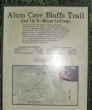
Mount LeConte - 6.9.2009
Drive the Newfound Gap road 8.5 miles south of the Sugarlands Visitor Center and find the trailhead next to the road.
|
At 6593 feet, Mt. LeConte is the third highest mountain in the state of Tennessee.
|
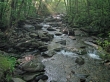
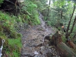
Walk along a stream in old-growth forest for the first mile...
|

and occasional small waterfalls...
|

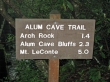
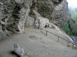
At 1.4 miles larman arrives at the Arch Rock.
|
The trail goes up through Arch Rock.
|

ragman coming up through Arch Rock.
|
larman at the Alum Cave Bluffs.
|
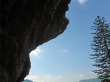
Looking up from underneath the Alum Cave Bluffs.
|
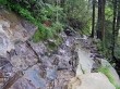
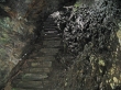
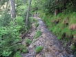
After leaving the bluffs, a lot of the trail is wet...
|
created by the weeping walls...
|
where cables help prevent slipping.
|
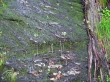
One of the weeping walls.
|
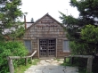
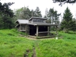
At 5 miles we found the LeConte Lodge...
|

that had a nice dining room...
|
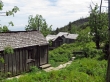
and several cabins that can be reserved...
|
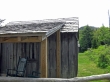
complete with rocking chairs and a view of the Mt. LeConte summit on the right.
|
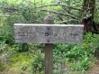
Continue .2 miles to...
|
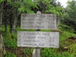
the LeConte Shelter... leaving .1 miles to the summit...
|

where larman adds a rock to the summit cairn (6593').
|

ragman adds a rock to the Mt. LeConte summit cairn.
|
We decided to take the side path to the Cliff Tops... in search of a view.
|

larman found a nice view at the Cliff Tops.
|

Clingmans Dome from the Cliff Tops.
|

We saw some rhododendrons along the trail.
|
