Barrier Peak - 7.25.2009
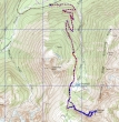
rodman's 2004 GPS route for Barrier Peak... the same route Denali Girl and I used today... 9.5 miles roundtrip, gaining 3027 feet of elevation.
|
From the White River entrance to Mt. Rainier Nat. Park... drive 2 miles to the Owyhigh Lakes trailhead (~3700').
|
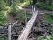
At ~2.75 miles, cross a footbridge... a good water source and the take-off point for the Tamanos Tarns.
|
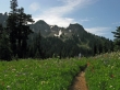
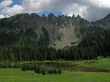
At ~3.25 miles, Denali Girl has come out of the trees and is surrounded by a huge flower field... Barrier Peak is in the left-center of the photo.
|
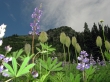
Lupine and Western Anemone near Owyhigh Lakes... Tamanos Mtn above.
|
Red Columbine and Western Anemone near Owyhigh Lakes... Tamanos Mtn above.
|
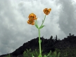
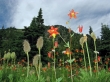
Tiger Lily... with the south side of Barrier Peak above.
|
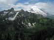
The Cowlitz Chimneys and Mt. Rainier as we climb towards Barrier Peak.
|
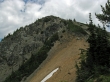
Almost to the Barrier Peak summit.
|
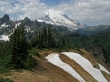
The Cowlitz Chimneys and Mt. Rainier as we near the Barrier Peak summit.
|
|
A pano shot from the Barrier Peak summit of The Cowlitz Chimneys, Mt. Rainier, Goat Island Mtn and Tamanos Mtn.
|
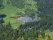
Looking down on Owyhigh Lakes from the Barrier Peak summit.
|
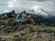
Denali Girl on the Barrier Peak summit (6521').
|
Owyhigh Lakes and Governors Ridge as we hike back to the car.
|
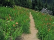
Red Columbine alley... 3.5 miles to get back to the car.
|
