Switzerland - Hohturli Pass and Blumlisalp Hut - 9.8.2009
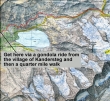
This map covers the first part of the hike... ride the gondola from Kandersteg (1176m) to the top of the station (1682m)... hike high around the north side of Oeschinensee (lake) and up to Hohturli Pass and the Blumlisalp Hut (2834m)... ~4 miles to the hut, gaining 3957 feet of elevation.
|
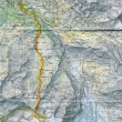
This map covers the second part of the hike... from the Blumlisalp Hut (2834m) to the village of Griesalp (1408m)... a loss of 4680 feet in ~5 miles.
|
The top of the gondola station in Kandersteg.
|
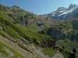
Before getting to Oeschinensee, turn left and hike high around the north side of the lake.
|
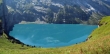
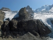
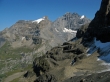
Left to right... Rothorn, Bluemlisalphorn, Oeschinenhorn, Frundenhorn and Doldenhorn... all are a part of the Bluemlisalp massif.
|
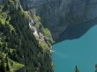
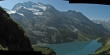
Falls at the east end of the lake.
|
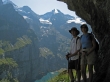
aceman and Denali Girl high above Oeschinensee... Bluemlisalphorn, Oeschinenhorn and Frundenhorn in the distance.
|
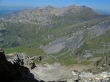
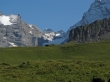
The Blumlisalp Hut is just to the right of Hohturli Pass... Wildi Frau is the flat looking mountain on the right... and Ufem Stock is to the right of Wildi Frau.
|
aceman on the trail to Hohturli Pass... Wildi Frau and Ufem Stock above his head.
|
Follow the leader...
|
aceman and Denali Girl head for the Ober Bergli hut down in the meadow.
|
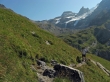
Still working our way around the lake.
|
Looking down on the Unter Bergli hut.
|
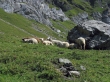
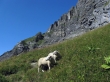
Sheep fighting for shade.
|
Doldenhorn above Oeschinensee... taken from the Ober Bergli hut.
|
|
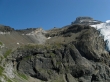
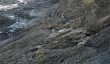
The ridge north of Oeschinensee.
|
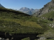
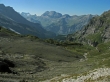
Looking west back down the valley towards Kandersteg.
|
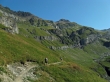
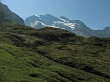
Continuing up towards Hohturli Pass... Wildi Frau, Ufem Stock and Wyssi Frau above.
|
Looking back on Doldenhorn.
|
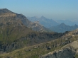
A pano shot with Hohturli Pass the low point in the center of the photo.
|
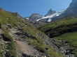
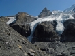
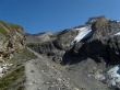
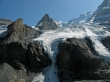
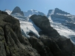
Getting closer to the Bluemlisalp Glacier.
|
High enough now to see valley floor at Kandersteg... the trail weaves along the right side.
|
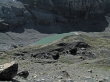
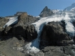
Looking down on glacier melt.
|
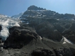
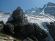
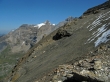
Ufem Stock in the middle... Wildi Frau on the left... Wyssi Frau and part of Bluemlisalphorn on the right... and the Bluemlisalp Glacier.
|
Rothorn blocking Bluemlisalphorn.
|
|
Wildi Frau, Ufem Stock, Wyssi Frau, a shoulder of Blumlisalphorn and Rothorn.
|
Wildi Frau, Ufem Stock, Wyssi Frau and a shoulder of Bluemlisalphorn.
|
A closeup of the Blumlisalp Hut...
|
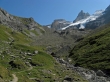
but there is still a long way to go to reach the hut.
|
Ufem Stock in the middle... partially blocking Wyssi Frau... and Bluemlisalphorn.
|
|
Left to right... Hohturli Pass, Blumlisalp Hut, Wildi Frau, Ufem Stock, part of Wyssi Frau, Bluemlisalphorn and Rothorn.
|
Wildi Frau, Ufem Stock and Bluemlisalphorn.
|
Ufem Stock, Bluemlisalphorn and Rothorn.
|
Hohturli Pass, the Blumlisalp Hut and Wildi Frau.
|
Wyssi Frau, Ufem Stock, Bluemlisalphorn and Rothorn.
|
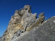
Interesting rock formation at Hohturli Pass.
|
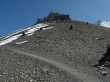
I've reached Hohturli Pass, but still have some elevation gain left to reach the Blumlisalp Hut.
|
From the Blumlisalp Hut... Wildi Frau, Wyssi Frau, Ufem Stock blocking part of Bluemlisalphorn and Rothorn.
|
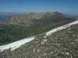
Looking down the valley towards Kandersteg from the Blumlisalp Hut... the ridge line on the right has Zallershore, Dundehore, Budstock and Schroarxhore.
|
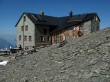
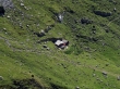
The Blumlisalp Hut.
|
|
Wyssi Frau, Ufem Stock partially blocking Bluemlisalphorn and Rothorn... from the Blumlisalp Hut.
|
Looking NE from the Blumlisalp Hut... across Zahm Andrist, Wild Andrist and Hundshore to Schilthorn and Birg.
|
A closeup of Schilthorn and Birg from the Blumlisalp Hut... Schwarzhorn is the pyramid in the distance to the right of Birg... Tschuggen and Lauberhorn are the two bumps closer in to the right of Birg.
|
I'm back down at Hohturli Pass... and ready to head down to the village of Griesalp.
|
Butlasse and Gspaltenhorn from Hohturli Pass.
|
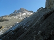
Looking down in the valley that will lead to the village of Griesalp.
|
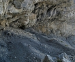
The trail switchbacks steeply down the north side of Hohturli Pass.
|
Looking back to Wildi Frau and the Blumlisalp Hut as I hike down from Hohturli Pass.
|
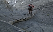
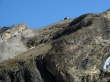
A hiker coming up on the north side of Hohturli Pass.
|
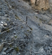
A hand line is very helpful on the steep north side of Hohturli Pass.
|
Hikers heading up on the north side of Hohturli Pass.
|
Butlasse and Gspaltenhorn... as I continue down to the valley that leads to Griesalp.
|
Only 20 minutes to reach some much needed refreshments at Bundalp... and then another hour to reach Griesalp.
|
Butlasse and Gspaltenhorn on the left of Gamchilucke Pass... with the east shoulder of Morganhorn and Wildi Frau on the right side of the pass... Tschingelhorn is on the other side of the pass.
|
A closeup of Tschingelhorn on the other side of Gamchilucke Pass.
|
