Shriner Peak - 9.26.2009
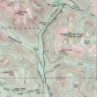
From Enumclaw, drive Hwy 410 east... enter Mt. Rainier Nat. Park just beyond the Crystal Mtn turnoff... turn right on Hwy 123 towards Cayuse Pass and drive 7.2 miles to the trailhead (2400')... the hike is 8.4 miles roundtrip, gaining 3434 feet of elevation.
|
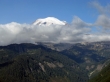
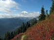
At ~4200 feet we got our first view of Mt. Rainier.
|
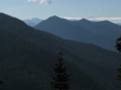
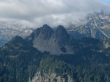
Looking south we could see Goat Rocks and Mt. Adams.
|
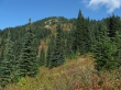
The Shriner Peak summit is up there beyond the trees.
|
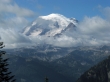
Mt. Rainier from near the Shriner Peak summit.
|
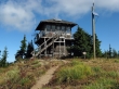
The Shriner Peak Lookout (5834').
|
A closeup of Mt. Rainier and Little Tahoma from the Shriner Peak summit.
|
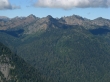
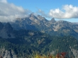
Tamanos Mtn, Barrier Peak and Governors Ridge.
|
A closeup of Double Peak.
|
The Cowlitz Chimneys.
|
