Tatoosh Peak - 10.10.2009
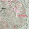
From Packwood, drive 4 miles on the paved Skate Creek Road and turn right onto FS 5270... continue 5.5 miles to a junction with 5270-990... stay to the right at the junction and drive another 1.5 miles to the trailhead on the right.
|
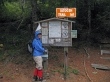
Denali Girl signs us in at the trailhead (2900') on this very chilly morning.
|
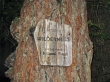
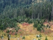
We are in the Tatoosh Wilderness... part of the Gifford Pinchot National Forest.
|
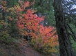
Vine Maple on fire.
|
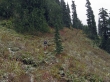
At 2 miles (5500') we will bypass the trail leading to Tatoosh Lakes.
|
Denali Girl continues on the trail in snow flurries.
|
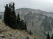
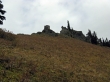
Snowing harder now as we get our first look at the summit... the small bump to the right of the big bump in the center of the photo.
|
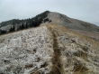
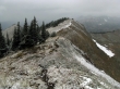
Looking back on our path as we traverse towards the south ridge of Tatoosh Peak.
|
At 4 miles we have reached the spur that leads to Tatoosh Peak.
|
Denali Girl on the south ridge of Tatoosh Peak... we will follow the ridge to the summit in the distance.
|
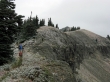
Three other hikers are close to the summit.
|
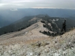
Looking south from the Tatoosh Peak summit (6310')... Oregon is in the sunshine.
|
Looking NW from the Tatoosh Peak summit... seriously, the Tatoosh Range and Mt. Rainier are really there.
|
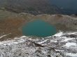
The tarn just north of the Tatoosh Peak summit.
|
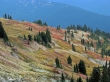
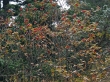
Fall colors near Tatoosh Peak.
|
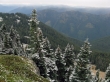
As we head back down it is still cold enough to keep the snow on the trees.
|
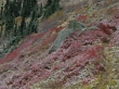
I don't expect you to believe it... but the black dot in the blueberry (red) patch below is a black bear.
|
Blueberry slushy.
|

Every see a blueberry frowning?
|
Not sure what it is... but it is pretty.
|
The saddle in the center of the photo is only 100 feet above the trail and should look down on Tatoosh Lakes.
|
Almost to the saddle that should look down on Tatoosh Lakes.
|
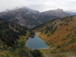
Tatoosh Lakes from the saddle... Tatoosh peaks left to right... Foss, Unicorn, Boundary and Stevens.
|
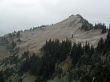
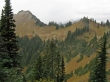
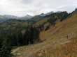
Looking back on Tatoosh Peak... the trail traverses from where we are standing to the ridge low point on the far right... then follows the ridge to the summit.
|
Tatoosh Peaks left to right... Wahpenayo, Lane, Plummer, Pinnacle, Foss, Unicorn and Boundary... 2 miles left to reach the car... 9.5 miles roundtrip, gaining ~3600 feet of elevation.
|
