Teanaway Peak - 10.20.2009
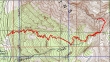
rodman's GPS route of our trip to Teanaway Peak... 6.2 miles roundtrip, gaining 2756 feet of elevation.
|
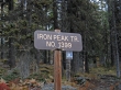
From 29 Pines Campground... drive the N. Fork Teanaway road for ~10.5 miles to the Iron Peak trailhead (3920') on the right side of the road.
|
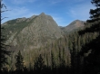
After hiking a half mile we got a nice view of the east end of Esmeralda Peaks on the left and Fortune Peak on the right.
|
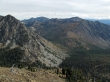
A closeup of Fortune Peak and South Ingalls Peak.
|
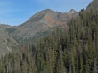
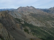
After hiking 2.5 miles we reached the saddle (~6200') between Iron Peak and Teanaway Peak... and got this view of Bill Peak, Devils Head, Volcanic Neck, Bean Peak, Mary Peak and Judy Peak.
|
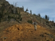
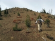
From the Iron/Teanaway saddle... rodman starts on the well-worn path that will lead over to the east ridge of Teanaway Peak.
|
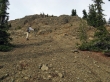
rodman continues on the path... which could almost be called a trail.
|
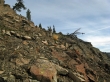
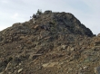
rodman standing between two of the many cairns that help guide the way to the east ridge of Teanaway Peak.
|
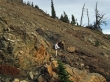
We will head for the snag in the upper left corner of the photo... Bill Peak on the right.
|
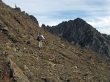
We can almost see the summit.
|
Getting closer.
|
rodman near the Teanaway Peak summit.
|
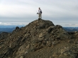
rodman on the Teanaway Peak summit (6779')... with Mt. Rainier in the distance.
|

ragman on the Teanaway Peak summit... with Mt. Stuart and Sherpa Peak beyond.
|
A pano shot of the Stuart Range... Bill Peak in the foreground... Three Brothers, Navaho and Earl on the right skyline.
|
Looking across Longs Pass to Fortune Peak and Ingalls Peak.
|
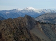
A closeup of The Citadel, Mt. Hinman, Mt. Daniel and Cathedral Rock.
|
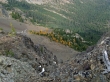
Larch trees on the north side of Teanaway Peak.
|
Looking south to Iron Peak.
|
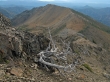
A closeup of the Larch trees on the north side of the ridge between Bean Peak and Mary Peak... Bill Peak on the left... Three Brothers, Navaho and Earl on the skyline.
|
