Microwave Hill and Keechelus Ridge - 12.9.2009
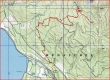
rodman's GPS route of our trip to Keechelus Ridge... 8.5 miles roundtrip, gaining 3028 feet of elevation.
|
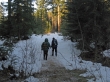
The hike starts from the Price Creek Sno-park (2600')... located ~.5 miles west of Exit 62 on the north side of I-90.
|
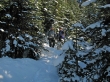
Shortly after crossing Nobel and Price creeks turn right and follow the road uphill.
|
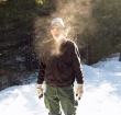
ragman is on fire!
|
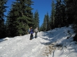
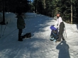
BarbE and rodman discuss whether or not to leave the road and go cross-country.
|
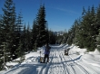
We decided to stay on the road and followed it all the way to...
|
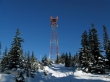
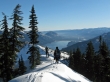
the radio tower on Microwave Hill (4960').
|
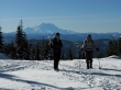
BarbE and rodman on Microwave Hill... with Ranier beyond.
|
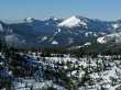
A pano shot taken near Microwave Hill... Mt. Thomson and Huckleberry Mtn on the left to Mt. Stuart and Thorp Mtn on the right.
|
A closeup of Mt. Stuart... with Thorp Mtn in the right foreground.
|
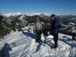
rodman and BarbE near the top of Microwave Hill.
|
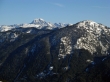
Bandera Mtn, Mt. Defiance and Granite Mtn from Microwave Hill.
|
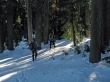
From Microwave Hill we hiked a half-mile through the woods to the high point on Keechelus Ridge.
|
ragman and BarbE near the high point (5151') on Keechelus Ridge... Kachess Lake is beyond... with part of Amabilis Mtn in the right foreground.
|
We took a more direct route on our return... cutting some switchbacks in the road.
|
