Mission Peak and Mission Ridge - 10.16.2010
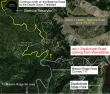
From Wenatchee, drive the Squilchuck road as if you were going to the Squilchuck State Park... but just before going thru the park gate, turn right onto the Mission Ridge road and drive to and turn right onto the gravel Liberty Beehive road... a.k.a FS 9712.
|
From the paved Mission Ridge road... the Devils Gulch trailhead #1220 is a 4.1 mile drive on the gravel Liberty Beehive road... continue driving another 2.7 miles to an unsigned path (~5800') that leads to Mission Peak.
|
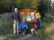
rocman, Denali Girl and Jannu at the Devils Gulch trailhead (~5000').
|
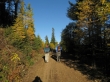
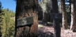
The Devils Gulch Trail starts out as a road, but narrows to more of a trail after a quarter mile.
|
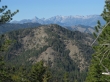
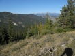
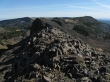
You don't have to hike very far to get a look at Point 4963... but it is still a couple of miles to get over to the summit... the Stuart Range is in the distance.
|
After hiking a couple of miles we will take the Mission Ridge Trail #1201.
|
We used the Mission Ridge Trail #1201 for ~.25 miles and are now going cross country to the Mission Ridge high point.
|
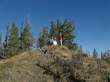
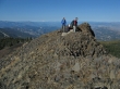
Denali Girl, rocman and Jannu on the Mission Ridge high point (4963').
|
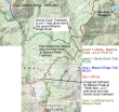
The Stuart Range from our high point on Mission Ridge... we will return to the car via the same route... ~5 miles roundtrip, gaining ~1160 feet of elevation.
|
We drove on the Liberty Beehive road for 2.7 miles from the Devils Gulch trailhead to this unofficial trail (~5800') on the left... which will take us to Mission Peak.
|
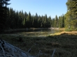
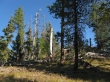
After hiking ~1 mile we came to this unnamed lake.
|
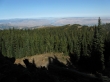
Nearing the Mission Peak summit... Wenatchee, the Columbia River and Waterville Plateau in the distance.
|
From the Mission Peak summit (6876')... distant views of the Dutch Miller Peaks, Stuart Range and Glacier Peak.
|
Denali Girl, rocman and Jannu on the Mission Peak summit.
|
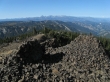
From the Mission Peak summit... looking over at the top of the Mission Ridge Ski Area (right)... ~4 miles roundtrip, gaining ~1050 feet of elevation.
|
