Red Top Mountain - 4.17.2011
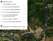
From Exit 85 on I-90... drive WA-970 E for ~10.5 miles... merge with US-97 N and continue for 6.7 miles (eighth of a mile beyond the Mineral Springs Restaurant) and turn left on to FS 9738.
|
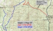
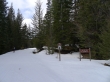
We were able to drive FS 9738 for .7 miles before being blocked by snow.
|
Denali Girl on FS9738... soon you will be able to drive 2 miles on FS 9738 before being stopped by the snow.
|
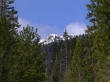
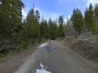
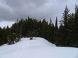
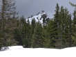
The first view of Red Top Mountain comes in the first mile.
|
After skiing FS 9738 for 2.3 miles (3 miles from Hwy 97), we turned left and started the 5 mile ski to Red Top Mtn on FS 9702.
|
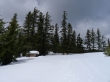
The parking area for Red Top Mountain... another half-mile from here to the summit.
|
The lookout on Red Top Mountain.
|
A closeup of the lookout on Red Top Mountain.
|
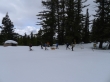
I ran into this motley crew of nwhikers coming down from the summit... Barry, Eric, Suzanne, David, Gus (4 legs), Barb, Jim and Elle... no idea where Izzy (4 legs) is... probably with me looking for M&Ms.
|
Reports of icy conditions on the summit made for an easy decision to forego the summit and ski back down the road with Carla... the trip was 14.5 miles roundtrip, gaining ~2240 feet of elevation.
|
