Sauer Mountain - 4.22.2011
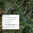
From downtown Leavenworth... drive US-2 east for 3.8 miles... turn left at the Peshastin Exit and cross the river... turn left to stay on Main Street and continue as it turns into North Road... follow North Road for a half mile... and just before the Peshastin Cemetery, turn right on to Anderson Canyon Road and continue 1.2 miles to the trailhead (~1350') on your left.
|
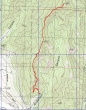
rodman's GPS route of our hike to Sauer Mountain... 5.25 miles roundtrip, gaining 1921 feet of elevation.
|
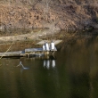
Just before reaching the Sauer Mtn trailhead you will see this penguin family...
|

...and other strange things.
|

Ladybugs for sale at the trailhead...
|

One of the Sauer Mountain guardians.
|

BarbE poses with the "Tired Wolf".
|
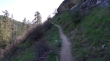
Heading uphill on the Sauer Mountain trail... the first mile or so is on private land... the Sauer family must really be nice folks.
|
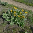
Balsamroot in bloom... the best flower show we've seen this year.
|
At the half-mile mark (1670'), you can take the short .2 mile walk to a viewpoint or continue towards the summit... or do both.
|
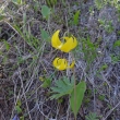
There were a ton of Glacier Lilies.
|
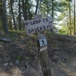
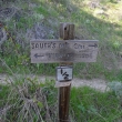
At the one mile mark (2070') a loop trip is possible, but we got a late start and were short of time today.
|
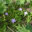
Waterleaf
|
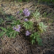
Hepatica... we don't see these in many places... but I suppose it is possible that we just don't go to the right places to see them.
|
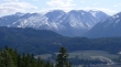
Wedge Mtn on the left... The Temple (I think) in the center... and Cannon Mtn (I think) on the right.
|
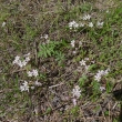
There were a ton of Spring Beauties.
|
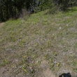
A hillside full of glacier lilies and spring beauties.l
|
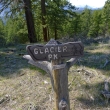
A viewpoint (2480') for Glacier Peak.
|
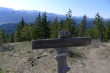
On the Sauer Mountain summit (3116').
|
Yes ladies... these are the legs that ragman uses for hiking.
|
