Teanaway Peak and Iron Peak - 10.9.2013
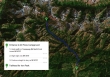
Directions from the entrance to 29 Pines Campground to the Iron Peak Trailhead.
|
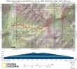
rodman's GPS route from October 2008... the same route we did on this trip... 7.5 miles roundtrip, gaining 3110 feet of elevation.
|
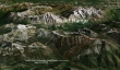
A google earth look at the terrain around Teanaway Peak and Iron Peak.
|
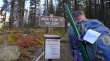
The Iron Peak Trailhead is on the right side of FS 9737... with a small parking area on the left side of the road.
|
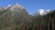
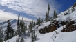
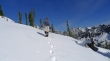
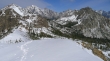
In less than a mile of hiking we got a nice view of Esmerelda East on the left... and Fortune Peak and South Ingalls Peak on the right.
|
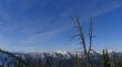
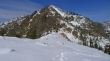
Looking south... just below the Teanaway/Iron saddle... Mt. Rainier in the distance on the left.
|
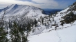
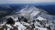
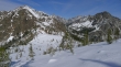
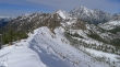
At the Teanaway/Iron saddle (6200')... Bills Peak in the foreground on the left... Devils Head, Volcanic Neck, Bean Peak, Marys Peak and Judys Peak on the ridge line across the valley.
|
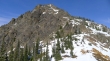
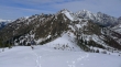
Iron Peak from the Teanaway/Iron saddle.
|
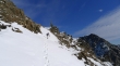
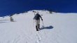
larman on the upwardly-biased traverse from the Teanaway/Iron saddle to the east ridge of Teanaway Peak.
|
larman continuing on the upwardly-biased traverse over to the east ridge of Teanaway Peak... Iron Peak in the distance on the left.
|
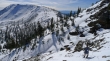
larman contouring underneath the cliffs on the SE side of Teanaway Peak... Bills Peak on the right.
|
Still contouring underneath the cliffs... and aiming for the tree... Bills Peak on the right.
|
larman on the east ridge of Teanaway Peak... above the tree now.
|
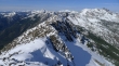
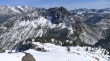
Continuing on the east ridge of Teanaway Peak... views of the Stuart Range are growing.
|
On easier terrain now... Iron Peak in the distance on the right.
|
Using rock when convenient... Looking beyond Volcanic Neck, Bean Peak and Marys Peak to Three Brothers, Navaho Peak and Earl Peak.
|
Continuing up on easy terrain.
|
Almost to the summit of Teanaway Peak.
|
Ever upward.
|
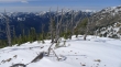
Maybe we should just follow the animal tracks.
|
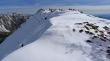
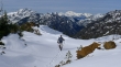
larman following the animal tracks.
|
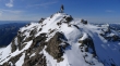
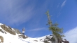
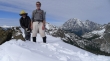
larman on the Teanaway Peak summit (6779').
|
larman on the Teanaway summit... South Ingalls in the distance on the far left... Stuart, Sherpa and Argonaut on the right.
|
Three Washington Huskies on the Teanaway Peak summit... but who is the little dude?... Dragontail Plateau and Little Annapurna in the distance on the left.
|
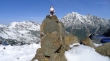
The little dude is a Husky Gnome... guardian of all things Husky!... Fortune and Ingalls on the left... with Stuart and Sherpa on the right.
|
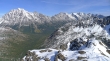
The Stuart Range from the summit of Teanaway Peak.
|
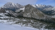
Looking NW... along the ridge that connects Teanaway Peak to Longs Pass... foreground peaks are DeRoux, Esmerelda, Hawkins, Fortune and Ingalls... Mt. Daniel is lit up in the center of the photo... with lots of Dutch Miller peaks in the distance on the left.
|
larman on the Teanaway Peak summit.
|
Iron Peak from Teanaway Peak.
|
larman heading down... Bills Peak in the foreground... Colchuck, Dragontail, Little Annapurna and McClellan on the left... with Three Brothers and Navaho on the right.
|
Continuing down... almost back to the tree.
|
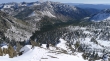
Past the tree now... contouring below the cliffs and heading for the Teanaway/Iron saddle in the center of the photo.
|
Heading for the Teanaway/Iron saddle... Iron Peak on the left.
|
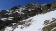
Underneath the cliffs and looking up.
|
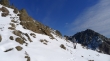
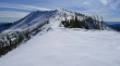
Back at the Teanaway/Iron saddle and looking at Teanaway Peak.
|
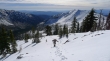
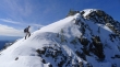
On the ridge leading to Iron Peak.
|
Looking back at Teanaway Peak as we head for Iron Peak.
|
We can see our route from the Teanaway/Iron saddle that contoured underneath the cliffs on the SE side of Teanaway Peak over to the tree.
|
As we gain elevation toward Iron Peak we can see more of the Stuart Range between Teanaway Peak on the left and Bills Peak on the right.
|
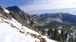
Looking west and NW from the ridge leading to Iron Peak.
|
High enough now to see Mt. Stuart beyond Teanaway Peak on the left.
|
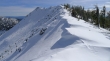
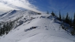
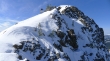
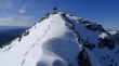
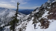
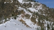
Cornice activity on the ridge leading to the Iron Peak summit.
|
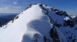
Almost to the Iron Peak summit... Looking across Judys Peak on the left to Earl Peak.
|
Looking back along the ridge that goes to the Teanaway/Iron saddle... Teanaway Peak in the center of the photo... Mt. Stuart and Sherpa Peak on the right.
|
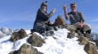
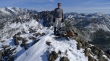
ragman and larman on the Iron Peak summit (6510')... Mt. Daniel in the distance on the far left.
|
A closeup of Mt. Hinman and Mt. Daniel from the Iron Peak summit.
|
The Stuart Range from the Iron Peak summit... Bills Peak in the foreground.
|
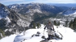
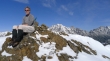
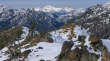
A pano shot taken just south of the Iron Peak summit.
|
larman leaving the Iron Peak summit and heading back to the Teanaway/Iron saddle.
|
Less than a half-mile to get back to the Teanaway/Iron saddle... leaving a 2.5 mile hike back to the car.
|
