West Tiger 1 & 2 - 1.13.2008
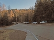
Only a few cars at the best starting point for West Tiger 1 & 2... Exit 20 off of I-90... this parking area is less than one-tenth of a mile from I-90... walk on paved road beyond the gate and shortly after passing High Point Pond, turn uphill to the right.
|
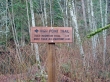
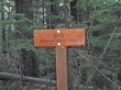
We are on the High Point Trail (not to be confused with the High Point Trailhead) and will have to go 1.1 miles to reach the TMT.
|
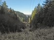
At the .4 mile mark we cross the power line road that parallels I-90... the parking area for the popular High Point Trailhead leading to West Tiger 3 is about a mile down this power line road.
|
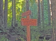
At the 1.1 mile mark we've reached the TMT and will turn left and head for Fred's Corner.
|
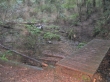
Crossing a stream at the 1.5 mile mark.
|

Mushroom
|
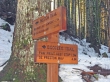
At the 2 mile mark we have reached Fred's Corner and the West Tiger Railroad Grade... we will turn left and go to the West Tiger 1 trail.
|
At the 3 mile mark we are 75 feet of elevation below the ridge... we will turn left on the Bootleg trail... go a short distance and then bushwhack up to the eastern most tower on the ridge.
|
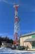
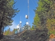
At the 3.2 mile mark (2800 feet) we are at the eastern most tower on the ridge.
|
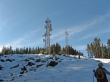
A second set of towers as we walk the road towards West Tiger 1.
|
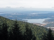
Lake Sammamish, Bellevue, and Lake Washington... taken on the ridge leading to West Tiger 1.
|
At the 3.5 mile mark we've reached the West Tiger 1 summit at 2948 feet,
|
The Hikers Hut at the 3.7 mile mark... the two towers on the right are on the summit of West Tiger 1.
|
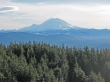
A closeup of Mt. Rainier from the Hikers Hut.
|
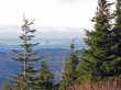
Seattle and Puget Sound from the Hikers Hut.
|
At the 4.3 mile mark we are nearing the towers on West Tiger 2... from the Hikers Hut we had to give up 300 feet of elevation and then regain 250 feet of it back.
|
West Tiger 2 summit at 2757 feet... the views aren't nearly as good here as they were from West Tiger 1 and the Hikers Hut.
|
From the West Tiger 2 summit we will take Tom's Crossing to the TMT... go on the TMT for a quarter mile and connect with the K-3 Trail for the most direct descent.
|
On the way down from West Tiger 2, the K-3 trail crosses over the West Tiger Railroad Grade at the 4.7 mile mark.
|
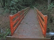
At the 5.7 mile mark this bridge crosses the High Point Creek... still have 1.2 miles left to reach the car... 6.9 miles roundtrip, gaining 2700 feet of elevation... with over 80 miles of trail on Tiger Mtn, it can be confusing without a map.
|
