Tronsen Head - 4.16.2008
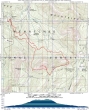
rodman's GPS route for our hike/snowshoe trip to Tronsen Head... 8.5 miles roundtrip, gaining 2300 feet of elevation... start from Swauk Pass (incorrectly marked as Blewett Pass on this map).
|
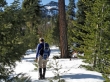
larman with Diamond Head (Pt. 5915) in the background... we started from Swauk Pass and walked FS9716 for a half-mile... then turned left and started following the XC ski track leading to Haney Meadows.
|
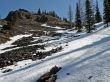
After 2.5 miles of hiking we come out of the trees and see the west end of bump 5920 that is between Diamond Head and Tronsen Head.
|
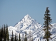
A zoom shot of Mt. Stuart taken a few hundred feet below the unnamed bump at 5920 feet... Navaho Peak is on the left and the southwest ridge that leads to the west summit of Three Brothers is on the right.
|
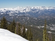
The Stuart Range and most of the Teanaway Peaks... taken from the bump (5920') between Diamond Head and Tronsen Head.
|
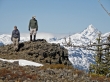
rodman and larman on the west end of bump 5920... Earl Peak is on the left... Ingalls Peak is in the clouds... Navaho Peak and Mt. Stuart are on the right.
|
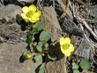
A couple of yellow flowers.
|
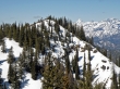
Looking back on bump 5920 as we make our way over to Tronsen Head (Pt. 5980).
|
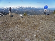
rodman and larman enjoy the views of the Stuart Range and Teanaway Peaks from Tronsen Head.
|
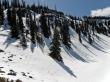
We quickly gave back 1000 feet of elevation on Tronsen Head's north side and then worked our way west on gentle terrain to complete the loop trip.
|
