Sherpani Peak - 7.8.2008
|
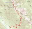
rodman's GPS route from last year to the east side of Point 6564... plus yesterday's general route from Point 6564 to the Sherpani summit (6720')... 9 miles roundtrip, gaining ~3500 feet of elevation.
|
From the trail to Paddy-Go-Easy Pass, we look down on Tucquala Lake and Goat Mtn above.
|
Mt. Daniel and Cathedral Rock from the Paddy-Go-Easy trail.
|
At ~5800' we've left the Paddy-Go-Easy Pass trail and are heading for this saddle between Paddy-Go-North (Pt 6573) and Point 6564.
|
Mt. Rainier from near the saddle between Paddy-Go-North and Point 6564.
|
|
Paddy-Go-North from the saddle.
|
Charlie and larman start the traverse towards Sherpani Peak on the east side of Point 6564... Sherpani Peak can barely be seen in the right-center of the photo.
|
Our first good look at Sherpani Peak... still some traversing to do on the east side of Point 6564 over to the saddle between Pt 6564 and Sherpani.
|
Charlie is traversing towards the saddle.
|
We've reached the saddle between Pt 6564 and Sherpani... we will stay on the snow to the right and work our way up to the ridge east of Sherpani.
|
|
Charlie and larman look at a portion of our route along the east side of Point 6564.
|
larman and Charlie are gaining elevation underneath the cliffy part of Sherpani Peak.
|
We've reached a nice bench area two hundred feet below the Sherpani summit.
|
larman and Charlie with the south summit of Granite Mtn beyond.
|
The upper of the two French Potholes at the foot of South Granite Mtn.
|
|
Very steep terrain on the northeast side of Sherpani Peak.
|
larman takes a break 150 feet below the Sherpani Peak summit.
|
We've dropped our packs as Charlie prepares to start the corkscrew route to the summit.
|
The Sherpani summit (6720') from the southeast side... we will go around to the right to the southwest side to make the final move to the top.
|
ragman stops to look through the boulder window as we work our way around to the southwest side of Sherpani.
|
|
Hyas lakes through the boulder window.
|
The Sherpani Peak summit cairn as Charlie prepares to make the final move up onto the top.
|
The first page of the Sherpani Peak summit register... placed in 1992... with entries from Gene and Jeri Prater.
|
Looking southeast towards the Stuart Range.
|
Charlie and larman on the Sherpani Summit with Mt. Daniel and Cathedral Rock in the distance.
|
|
ragman on the Sherpani summit with The Cradle on the left and Mt. Stuart on the right.
|
The Cradle, Harding Mtn, Solomon Mtn, Scatter Peaks and Tucquala Mtn in the foreground... The Stuart Range, Ingalls Peak and Fortune Peak in the distance.
|
A closeup of Mt. Stuart.
|
Looking west towards some of the Middle Fork Snoqualmie Peaks.
|
The south summit of Granite Mtn with Glacier Peak in the distance on the right.
|
|
Cathedral Rock, Mt. Daniel and the Hyas Lakes.
|
larman snaps a photo of Mt. Daniel from the Sherpani summit.
|
The Cradle from the Sherpani Peak summit.
|
larman and Charlie do some boot-skiing as we leave the Sherpani summit.
|
Back at the bench 200 feet below the Sherpani summit we can see our route back to the saddle between Pt 6564 and Sherpani.
|
|
Nearing the saddle between Pt 6564 and Sherpani.
|
Traversing underneath Point 6564.
|
Looking back on our route to Sherpani Peak.
|
Sherpani Peak with the general route marked in red.
|
Traversing the final portion of the route on the east side of Point 6564... heading for the saddle in the center of the photo.
|


