Sopwith Camel Mountain - 7.19.2008
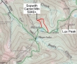
Map showing general off-trail route to Sopwith Camel Mtn... 6.5 miles roundtrip, gaining 2080 feet of elevation.
|
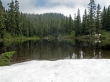
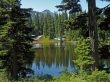
Starting from the end of FS Road #6095 at 3100'... we reached Hope Lake (4400') after hiking 1.6 miles.
|
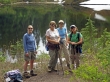
Erin, Anna, Denali Girl, and Nanda at Hope Lake.
|
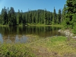
A half-mile from Hope Lake is Mig Lake (4661').
|
Looking back on Mig Lake as we head north, off trail, towards Sopwith Camel Mtn... the top of K9 is in the distance.
|
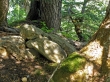
The top (5040') of Sopwith Camel Mtn is in the trees... the summit register is in this pile of rocks.
|
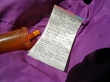
The Sopwith Camel Mtn summit register... placed in 2003... in a pill bottle... still room for plenty of signatures.
|
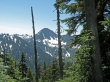
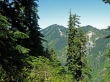
You have to work for views from Sopwith Camel Mtn... this is K9.
|
The south side of Cowboy Mtn from Sopwith Camel Mtn.
|
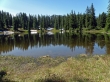
Looking beyond Mig Lake to the Sopwith Camel Mtn summit which is somewhere up there in the trees.
|
