Labyrinth Mtn - 8.5.2008
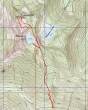
rodman's GPS route to Labyrinth Mtn... 5.5 miles roundtrip, gaining 2686 feet of elevation.
|
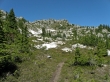
Gaining 1750 feet of elevation in 1.75 miles brings you to Minotaur Lake (5550')... with Labyrinth Mtn summit at the end of the lake.
|
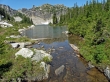
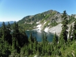
Hiking along the east shore of Minotaur Lake gives a view of Theseus... 500 feet below.
|
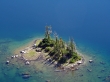
A closeup of the island on Theseus Lake.
|
Point 6262 SW from Minotaur Lake.
|
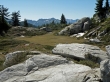
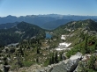
400 feet above Minotaur Lake is a nice meadow with a view of Rock Mtn.
|
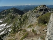
The Labyrinth Mtn summit (6376')... still a few hundred feet of elevation gain is left to reach the summit.
|
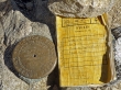
The Labyrinth Mtn summit register was placed in 1999 by Fay and Walter Pullen.
|
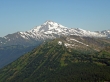
A closeup of Glacier Peak from the Labyrinth Mtn summit.
|
Looking south from Labyrinth Mtn... Theseus Lake on the left and Minotaur Lake in the center.
|
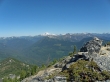
The ridge from Labyrinth Mtn leading over to Point 6262... Mt. Daniel, Mt. Hinman, and Mt. Rainier in the distance.
|
Glacier Peak from the Labyrinth Mtn summit.
|

rodman on the ridge between the Labyrinth summit and Point 6262... Sloan Peak in the distance.
|
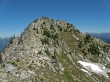
The Labyrinth Mtn summit as we hike south along the ridge.
|
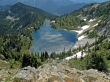
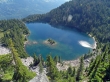
Minotaur Lake... taken from ~400 feet above the lake... time to get back down to the lake and back to the car.
|
