Jolly Mountain and Humerus Hill - 9.3.2008
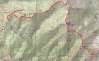
The first gate (2800') on FS 4315 was open... so we drove to the second gate (4600') and parked... hiked 4315 for .5 miles to Sasse Ridge... turned left and followed the Jolly Mtn signs... 11 miles roundtrip, gaining 3913 feet of elevation.
|
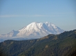
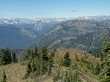
Shortly after leaving the car we got this view of Mt. Rainier from FS 4315.
|
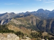
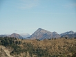
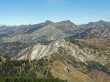
After hiking ~4 miles we've reached the Jolly Mtn summit (6443')... The Louvre is in the foreground... with Hawkins Mtn on the left and Mt. Stuart on the right.
|
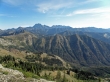
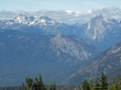
The Stuart Range from Jolly Mtn.
|
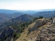
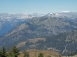
Looking SE from Jolly Mtn we will have to give back 800+ feet of elevation to reach our next target... Humerus Hill in the center of the photo.
|
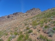
We've hiked ~1.5 miles from Jolly Mtn and are on the south side of Humerus Hill... time to leave the trail and head for the summit.
|
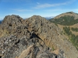
We are on a false summit of Humerus Hill (5920+), but it will be easy to get over to the true summit on the left... Jolly Mtn is on the right.
|
A closeup of The Cradle from Humerus Hill.
|
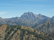
A closeup of Mt. Stuart from Humerus Hill.
|
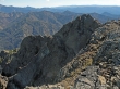
The north side of Humerus Hill is steep and rugged.
|
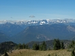
We've left Humerus Hill and hiked back up to the Jolly Mtn summit... looking west to some of the Middle Fork Snoqualmie and Dutch Miller peaks.
|
Looking across Cone Mtn and Davis Peak to the 3 summits of Summit Chief Mtn, Bears Breast Mtn, Mt. Hinman, Mt. Daniel, and Cathedral Rock.
|
A closeup of Hawkins Mtn from Jolly Mtn.
|
A closup looking across Cone Mtn to Dutch Miller Gap... which is between the 3 summits of Summit Chief Mtn on the left and Bears Breast Mtn on the right.
|
A closeup looking across Davis Peak to Mt. Hinman on the left and Mt. Daniel on the right.
|
