Alta Mountain - 9.10.2008
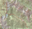
Starting from the Rachel Lake Trailhead (2750') there is a trail all the way to the Alta Mtn summit (6151')... 11 miles roundtrip, gaining 3519 feet of elevation.
|
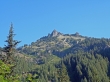
After hiking the Rachel Lake trail for ~2 miles we got a nice view of Hibox Mtn.
|
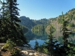
After hiking for ~4 miles we arrived at Rachel Lake (4680').
|
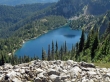
Looking down on Rachel Lake from the ridge leading to Alta Mtn.
|

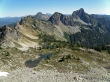
larman and one of the several bumps leading to the Alta Mtn summit.
|
Lila Lake from the ridge leading to Alta Mtn.
|
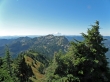
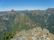
Looking south to Rampart Ridge and Mt. Rainier.
|

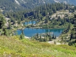
A closeup of a couple of the Rampart Lakes from the ridge leading to Alta Mtn.
|
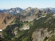
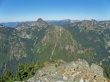
East Alta, Three Queens, Point 6242 and Hibox Mtn... The Cradle and Mt. Stuart are on the horizon... the tarns above Lila Lake are below.
|
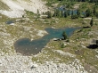
A closeup of the tarns above Lila Lake.
|
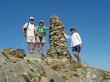
larman, Nanda, and rodman on the Alta Mtn summit (6151').
|
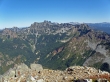
Looking north and NW from the Alta Mtn summit.
|

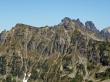
A closeup of Three Queens.
|
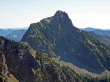
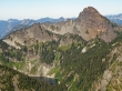
A closeup of Hibox Mtn.
|
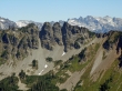
A closeup of Chikamin Peak in front of Lemah Mtn and maybe Chimney Rock... a portion of the PCT is cutting across Chikamin.
|
Mt. Thomson, Huckleberry Mtn, Big Snow Mtn, Burnt Boot Mtn and the NW ridge of Chikamin Peak.
|
A closeup of Bryant Peak, Chair Peak, Kaleetan Peak, Mt. Snoqualmie, Red Mtn, Lundin Peak and the Kendall Katwalk.
|
A closeup of Four Brothers... in front of Mt. Hinman, Bears Breast Mtn and Mt. Daniel.
|
A closeup of Mt. Thomson and Alaska Lake.
|
Mt. Thomson, Big Snow Mtn, Huckleberry Mtn and Burnt Boot Mtn.
|
