Mount Borah - 9.16.2008
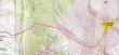
General route of our climb of Mt. Borah... at 12,662 feet, it is the highest point in Idaho... 8.2 miles roundtrip, gaining 5662 feet of elevation.
|
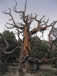
Some interesting trees along the steep trail.
|
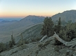
Looking north as we get above the treeline at ~9600'.
|

larman is ~400 feet below the point where the trail gradient will ease a bit at 10,000'.
|
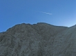
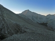
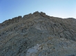
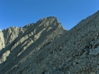
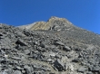
At ~10,000' we get our first good look at the Mt. Borah summit.
|
Mt. Idaho to the southeast... we've hiked for ~2.6 miles and are at 10,600 feet... the trail on the left starts getting steeper again.
|
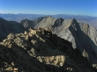
The sun is starting to hit Points 11367 and 11308 to the south.
|
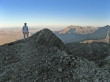
larman on the ridge leading to Chick-Out-Ridge... Point 10632 is behind him.
|
At 10,600' we are still 1200' below Chicken-Out-Ridge.
|
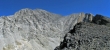
A pano shot of Mt. Borah and Chicken-Out-Ridge... taken from 10,600'.
|
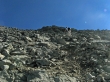
At ~11,400' the trail basically disappears... and we are still 600' below Chicken-Out-Ridge... we will climb up the knife-edge ridge on the left.
|
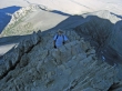
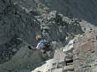
larman is on the knife-edge ridge... almost up to Chicken-Out-Ridge at 11,900'... the valley floor is 5000' below.
|
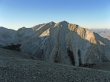
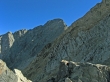
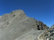
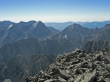
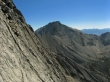
We've reached the south end of Chicken-Out-Ridge... Points 11367 and 11308 are to the south... the Sawtooth Range is in the distance.
|
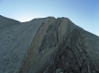
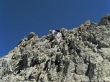
larman checks out the south end of Chicken-Out-Ridge... the crux of the climb is the black rock formation on the right side of the photo... Point 11898 is on the left.
|
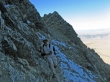
larman is on boot-path and dealing with a 10 foot stretch of ice on the north side of the black rock formation.
|
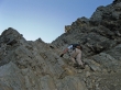
Then larman climbs for a short distance on the black rock formation.
|
From the east end of the black rock formation, we will need to down-climb a short distance... the Mt. Borah summit is in the distance.
|
larman starts the down-climb... and will cross the rib on the left and then climb back up to a col between the black rock formation and Point 11898.
|
We've reached the col between the black rock formation and Point 11898... now there is good boot-path all the way to the Mt. Borah summit.
|
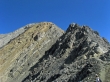
At the north end of Point 11898 there is a flat stretch leading over to the last 800 feet of elevation gain to the summit.
|
larman only has about 400' of elevation gain left to reach the Mt. Borah summit.
|
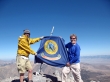
ragman, the Idaho State Flag, and larman on the Mt. Borah summit (12,662').
|
From the Borah summit we are looking SSE to Leatherman Pass in the center of the photo... Leatherman Peak is left of the pass and White Cap Peak is to the right of the pass.
|
A pano shot from the Borah summit showing a lot of the Lost River Range.
|
From the Borah summit we are looking south... across Chicken-Out-Ridge... to Points 11367 and 11308.
|
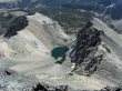
Lake 10204 on the east side of Mt. Borah.
|
larman on the knife-edge ridge leading down from the black rock formation to Point 10632.
|
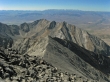
Mt. Idaho from the knife-edge ridge leading down from the black rock formation to Point 10632.
|
Looking back to Chicken-Out-Ridge... finally back on reasonable path.
|
One last look at Mt. Borah and Chicken-Out-Ridge before we drop below the treeline and head back to the car... a long 10 hour day.
|
