Teanaway Peak and Iron Peak - 10.22.2008
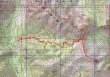
rodman's GPS route for Teanaway Peak and Iron Peak... 7.5 miles roundtrip, gaining 3210 feet of elevation.
|
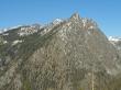
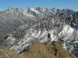
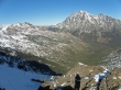
The east end of Esmeralda Peaks.
|
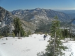
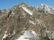
Nanda and rodman on the cliffy SE side of Teanaway Peak.
|
rodman is on the east ridge of Teanaway Peak... and heading for the summit.
|
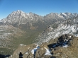
Nanda coming up the east ridge of Teanaway Peak... Three Brothers, Navaho, Bean, Earl, Mary and Judy peaks are in the distance.
|
Nanda nears the Teanaway Peak summit (6779').
|
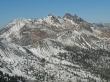
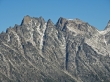
A closeup of Fortune Peak and the three summits of Ingalls Peak.
|
Mt. Stuart, Sherpa Peak, Argonaut Peak, Colchuck Peak, Dragontail and Little Annapurna.
|
Fortune Peak, Ingalls Peak, Mt. Stuart and Sherpa Peak... Glacier Peak is in the distance.
|
A closeup of Little Annapurna.
|
A closeup of Dragontail.
|
A closeup of Argonaut Peak and Colchuck Peak.
|
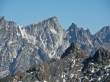
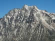
A closeup of Sherpa Peak.
|
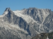
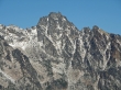
A closeup of Mt. Stuart.
|
Iron Peak from the Teanaway Peak summit.
|
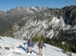
Nanda and rodman on the way back down Teanaway Peak.
|
Teanaway Peak and Mt. Stuart... taken along the trail to Iron Peak.
|
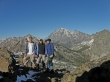
Iron Peak (6510') group photo... rodman, Nanda and ragman.
|
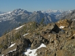
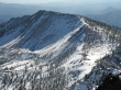
Hawkins Mtn, Esmeralda Peaks and Mt. Daniel from Iron Peak.
|
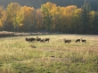
rodman's photo of deer grazing in the Teanaway Valley.
|
